Pebble Beach to Fisherman's Bay, June 10th 1995
Click on the small image to see the full-sized one.
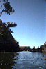
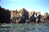
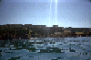 And the beach viewed from out at sea.
Links to related images: Nearby. Proofs. Map.
Approximate location: 38.6478462219238N / 123.402816772461W.
 The beach in the far corner of the bay.
Links to related images: Nearby. Proofs. Map.
Approximate location: 38.6475105285645N / 123.397834777832W.
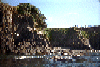
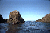
 Any gap in the rocks, I went through there.
Links to related images: Nearby. Proofs. Map.
Approximate location: 38.6485824584961N / 123.399040222168W.
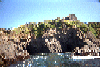
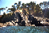
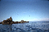
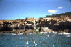
 I think the buildings are part of a still functioning ranch.
Links to related images: Nearby. Proofs. Map.
Approximate location: 38.649658203125N / 123.400413513184W.
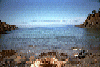
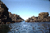
 Calm water and beautiful bluffs in Fishermans Cove
Links to related images: Nearby. Proofs. Map.
Approximate location: 38.6495895385742N / 123.401008605957W.
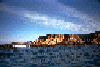
 Looking back out of Fishermans Cove
Links to related images: Nearby. Proofs. Map.
Approximate location: 38.6489868164062N / 123.402046203613W.
 Coastline near Fishermans Cove
Links to related images: Nearby. Proofs. Map.
Approximate location: 38.6422843933105N / 123.401954650879W.
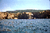
 Mild waves approaching Sea Ranch Pebble Beach
Links to related images: Nearby. Proofs. Map.
Approximate location: 38.6837997436523N / 123.452003479004W.
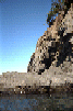
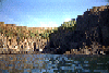
 Cliffs south of Sea Ranch
Links to related images: Nearby. Proofs. Map.
Approximate location: 38.6837997436523N / 123.452003479004W.
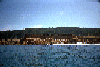
 Ready to launch at Sea Ranch Pebble Beach
Links to related images: Nearby. Proofs. Map.
Approximate location: 38.6837997436523N / 123.452003479004W.
 Stewarts Point
Links to related images: Nearby. Proofs. Map.
Approximate location: 38.6837997436523N / 123.452003479004W.
All text and images Copyright © 1995 by Mike Higgins / contact