Cliff House to Fort Mason, July 15th 1995
Click on the small image to see the full-sized one.
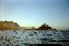
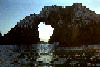
 The view back under the bridge from inside the bay:
Links to related images: Nearby. Proofs. Map.
Approximate location: 37.7904014587402N / 122.472999572754W.
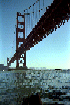
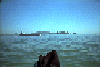
 A series of pictures as I paddled towards the Golden Gate Bridge:
Links to related images: Nearby. Proofs. Map.
Approximate location: 37.7904014587402N / 122.472999572754W.
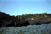
 Fort Miley Vetrans Hospital, and very expensive houses looking over
the Golden
Fort Miley Vetrans Hospital, and very expensive houses looking over
the Golden
Links to related images: Nearby. Proofs. Map.
Approximate location: 37.7904014587402N / 122.472999572754W.
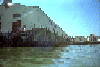 Fort Mason
Links to related images: Nearby. Proofs. Map.
Approximate location: 37.7904014587402N / 122.472999572754W.
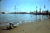 Aquatic park beach, with kayak
Links to related images: Nearby. Proofs. Map.
Approximate location: 37.7904014587402N / 122.472999572754W.
 Tall ships in Hide Street pier
Links to related images: Nearby. Proofs. Map.
Approximate location: 37.7904014587402N / 122.472999572754W.
 View of Alcatraz Island
Links to related images: Nearby. Proofs. Map.
Approximate location: 37.7904014587402N / 122.472999572754W.
All text and images Copyright © 1995 by Mike Higgins / contact