Bolinas Bay to Wildcat Camp, August 27, 1995
Click on the small image to see the full-sized one.
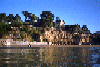
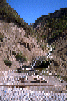 The shrine on the gravel beach north of Bolinas
Links to related images: Nearby. Proofs. Map.
Approximate location: 37.9356689453125N / 122.755905151367W.
 The gravel beach north of Bolinas
Links to related images: Nearby. Proofs. Map.
Approximate location: 37.9356002807617N / 122.756683349609W.
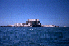
 Southern end of Point Reyes National Seashore
Links to related images: Nearby. Proofs. Map.
Approximate location: 37.9356842041016N / 122.764274597168W.
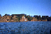 Buildings above the bluff just south of Point Reyes National Seashore
Links to related images: Nearby. Proofs. Map.
Approximate location: 37.9111404418945N / 122.731941223145W.
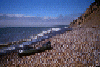
 Marty on Bolinas Beach
Links to related images: Nearby. Proofs. Map.
Approximate location: 37.9024887084961N / 122.683982849121W.
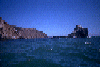
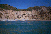
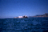 Stormy Stack, off Double Point, Point Reyes National Seashore
Links to related images: Nearby. Proofs. Map.
Approximate location: 37.9422836303711N / 122.77758026123W.
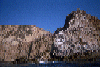 Double Point, Point Reyes National Seashore
Links to related images: Nearby. Proofs. Map.
Approximate location: 37.943775177002N / 122.777137756348W.
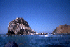 Rock off Double Point, Point Reyes National Seashore
Links to related images: Nearby. Proofs. Map.
Approximate location: 37.9427337646484N / 122.776443481445W.
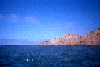 Stormy Stack off Double Point ahead of me.
Links to related images: Nearby. Proofs. Map.
Approximate location: 37.9421997070312N / 122.774215698242W.
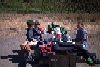
 Altamere Falls, and a group of friends hiking up the beach to see the
falls, the
Altamere Falls, and a group of friends hiking up the beach to see the
falls, the
Links to related images: Nearby. Proofs. Map.
Approximate location: 37.9580039978027N / 122.786796569824W.
All text and images Copyright © 1995 by Mike Higgins / contact