Mike's Kayak Journal, all photos taken on 1996-01-1
Click on the small image to see the full-sized one.
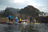 Suiting up at Horseshoe cove
Links to related images: Nearby. Proofs. Map.
Approximate location: 37.833667755127N / 122.477493286133W.
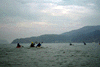
 Crossing horseshoe cove
Links to related images: Nearby. Proofs. Map.
Approximate location: 37.8329811096191N / 122.476509094238W.
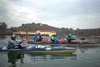
 Crossing Raccoon Strait
Links to related images: Nearby. Proofs. Map.
Approximate location: 37.8603515625N / 122.452072143555W.
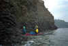
 Rounding a corner of Angel Island
Links to related images: Nearby. Proofs. Map.
Approximate location: 37.8607597351074N / 122.446662902832W.
 X2 in crack at Angel Island new years
Links to related images: Nearby. Proofs. Map.
Approximate location: 37.8604888916016N / 122.445541381836W.
All text and images Copyright © 1996 by Mike Higgins / contact