Navaro River to Elk, April 6th 1997
Click on the small image to see the full-sized one.
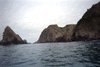
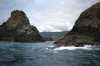
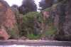
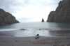
 Landed in side cave beach near Cuffey Point.
Links to related images: Nearby. Proofs. Map.
Approximate location: 39.1558990478516N / 123.744003295898W.
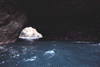
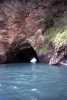
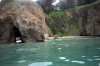
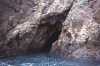
 The 'side cave' runs sidways into a beach near Cuffey Cove.
Links to related images: Nearby. Proofs. Map.
Approximate location: 39.1558990478516N / 123.744003295898W.
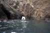
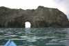
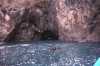
 Looking through 'side cave' to the beach behind, near Cuffey Cove.
Links to related images: Nearby. Proofs. Map.
Approximate location: 39.1558990478516N / 123.744003295898W.
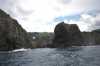
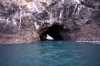
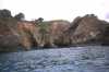
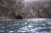
 Cave through one of the points of Cuffey Cove.
Links to related images: Nearby. Proofs. Map.
Approximate location: 39.1558990478516N / 123.744003295898W.
 Looking back through cave through one finger of Cuffey Point.
Links to related images: Nearby. Proofs. Map.
Approximate location: 39.1558990478516N / 123.744003295898W.
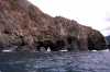
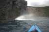
 Waves breaking out caves at Cuffeys Point.
Links to related images: Nearby. Proofs. Map.
Approximate location: 39.1558990478516N / 123.744003295898W.

 Narrow crack in Cuffeys Point, not navigable.
Links to related images: Nearby. Proofs. Map.
Approximate location: 39.1558990478516N / 123.744003295898W.
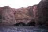
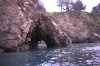
 Cave to sinkhole near Cuffeys Cove.
Links to related images: Nearby. Proofs. Map.
Approximate location: 39.1558990478516N / 123.744003295898W.
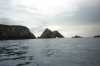
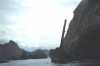
 Devils Basin, north of Cuffeys Cove.
Links to related images: Nearby. Proofs. Map.
Approximate location: 39.1558990478516N / 123.744003295898W.
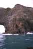
 Arch near Devils Basin.
Links to related images: Nearby. Proofs. Map.
Approximate location: 39.1558990478516N / 123.744003295898W.

 Arch near Saddle Point.
Links to related images: Nearby. Proofs. Map.
Approximate location: 39.1558990478516N / 123.744003295898W.
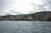
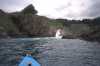
 Approaching Saddle Point.
Links to related images: Nearby. Proofs. Map.
Approximate location: 39.1558990478516N / 123.744003295898W.
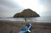
 Point south of the Navaro River mouth.
Links to related images: Nearby. Proofs. Map.
Approximate location: 39.1558990478516N / 123.744003295898W.


 Landing on secluded beach near Cuffey Cove.
Links to related images: Nearby. Proofs. Map.
Approximate location: 39.1558990478516N / 123.744003295898W.
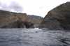
 Caves at Devils Basin.
Links to related images: Nearby. Proofs. Map.
Approximate location: 39.1558990478516N / 123.744003295898W.
 Cave in Devils Basin.
Links to related images: Nearby. Proofs. Map.
Approximate location: 39.1558990478516N / 123.744003295898W.
 Close to rocks on Saddle Point.
Links to related images: Nearby. Proofs. Map.
Approximate location: 39.1558990478516N / 123.744003295898W.
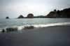 Greenwood Beach
Links to related images: Nearby. Proofs. Map.
Approximate location: 39.1558990478516N / 123.744003295898W.
 My kayak on the steep beach at Greenwood Cove.
Links to related images: Nearby. Proofs. Map.
Approximate location: 39.1558990478516N / 123.744003295898W.
 Couple and their terrier Asta on the beach at Greenwood Cove.
Links to related images: Nearby. Proofs. Map.
Approximate location: 39.1558990478516N / 123.744003295898W.
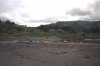
 South end of Greenwood Cove.
Links to related images: Nearby. Proofs. Map.
Approximate location: 39.1558990478516N / 123.744003295898W.
 A cave or arch in Gunderson Rock.
Links to related images: Nearby. Proofs. Map.
Approximate location: 39.1558990478516N / 123.744003295898W.
 One end of Gunderson Rock
Links to related images: Nearby. Proofs. Map.
Approximate location: 39.1558990478516N / 123.744003295898W.
 Filigree arches in Greenwood Cove, from a distance.
Links to related images: Nearby. Proofs. Map.
Approximate location: 39.1558990478516N / 123.744003295898W.
 Small arches in Warf Rock in Greenwood Cove.
Links to related images: Nearby. Proofs. Map.
Approximate location: 39.1558990478516N / 123.744003295898W.
 The telephone pole and chains on the entrance to Warf Rock in Greenwood Cove.
Links to related images: Nearby. Proofs. Map.
Approximate location: 39.1558990478516N / 123.744003295898W.
 Approaching the large arch in Warf Rock in Greenwood Cove.
Links to related images: Nearby. Proofs. Map.
Approximate location: 39.1558990478516N / 123.744003295898W.
 Another exit from Secret Cove back to Greenwood Cove.
Links to related images: Nearby. Proofs. Map.
Approximate location: 39.1558990478516N / 123.744003295898W.
 View back out cave from inside Secret Cove.
Links to related images: Nearby. Proofs. Map.
Approximate location: 39.1558990478516N / 123.744003295898W.
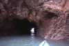
 Cave that leads to a Secret Cove.
Links to related images: Nearby. Proofs. Map.
Approximate location: 39.1558990478516N / 123.744003295898W.
 An arch near Cuffey Cove.
Links to related images: Nearby. Proofs. Map.
Approximate location: 39.1558990478516N / 123.744003295898W.
 Arches in Greenwood Cove.
Links to related images: Nearby. Proofs. Map.
Approximate location: 39.1558990478516N / 123.744003295898W.
 The inside of Cuffey Cove.
Links to related images: Nearby. Proofs. Map.
Approximate location: 39.1558990478516N / 123.744003295898W.
 Arch at Cuffey Cove.
Links to related images: Nearby. Proofs. Map.
Approximate location: 39.1558990478516N / 123.744003295898W.
 Blowhole near Cuffey Cove.
Links to related images: Nearby. Proofs. Map.
Approximate location: 39.1558990478516N / 123.744003295898W.
 Gap between two fingers of Cuffeys Point.
Links to related images: Nearby. Proofs. Map.
Approximate location: 39.1558990478516N / 123.744003295898W.
 Looking into and back out of Cuffeys Inlet.
Links to related images: Nearby. Proofs. Map.
Approximate location: 39.1558990478516N / 123.744003295898W.
 The entrance to the short cut through Cuffeys Point.
Links to related images: Nearby. Proofs. Map.
Approximate location: 39.1558990478516N / 123.744003295898W.
 Arch that connects to another inlet of Cuffeys Point.
Links to related images: Nearby. Proofs. Map.
Approximate location: 39.1558990478516N / 123.744003295898W.
 More caves in Cuffeys Point.
Links to related images: Nearby. Proofs. Map.
Approximate location: 39.1558990478516N / 123.744003295898W.
 Blowhole near Cuffeys Point.
Links to related images: Nearby. Proofs. Map.
Approximate location: 39.1558990478516N / 123.744003295898W.
All text and images Copyright © 1997 by Mike Higgins / contact