Usal Beach to Wages Creek, May 31 to June 1st 1997.
Click on the small image to see the full-sized one.
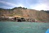
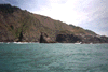
 Inside the big arch in Cape Vizcaino
Links to related images: Nearby. Proofs. Map.
Approximate location: 39.7269439697266N / 123.832588195801W.
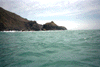
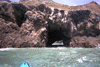 Heading towards the big arch on Cape Vizcaino
Links to related images: Nearby. Proofs. Map.
Approximate location: 39.7266616821289N / 123.833602905273W.
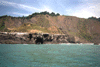
 The big arch on Cape Vizcaino from a distance
Links to related images: Nearby. Proofs. Map.
Approximate location: 39.7264823913574N / 123.834884643555W.
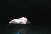
 Rocks offshore at Cape Vizcaino
Links to related images: Nearby. Proofs. Map.
Approximate location: 39.7284698486328N / 123.833770751953W.
 Cape Vizcaino viewed from the north
Links to related images: Nearby. Proofs. Map.
Approximate location: 39.7347145080566N / 123.834754943848W.
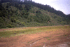 Charles and Sean coming across the Rockport Meadow
Links to related images: Nearby. Proofs. Map.
Approximate location: 39.7357292175293N / 123.827941894531W.
All text and images Copyright © 1997 by Mike Higgins / contact