Vallejo to Benicia, June 21st 1997.
Click on the small image to see the full-sized one.
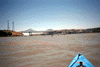
 Benicia Landing
Links to related images: Nearby. Proofs. Map.
Approximate location: 38.0439987182617N / 122.16300201416W.
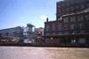
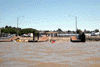
 Maritime Museum of abandoned boats
Links to related images: Nearby. Proofs. Map.
Approximate location: 38.0469017028809N / 122.16300201416W.
 Port Costa Landing
Links to related images: Nearby. Proofs. Map.
Approximate location: 38.0541839599609N / 122.201858520508W.
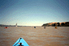 Up Carquinez Strait
Links to related images: Nearby. Proofs. Map.
Approximate location: 38.0584335327148N / 122.208656311035W.
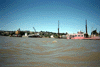
 Sugar Plant
Links to related images: Nearby. Proofs. Map.
Approximate location: 38.0580177307129N / 122.218338012695W.
 Across Carquinez
Links to related images: Nearby. Proofs. Map.
Approximate location: 38.0670127868652N / 122.236549377441W.
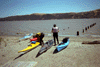
 Launching from Vallejo
Links to related images: Nearby. Proofs. Map.
Approximate location: 38.096004486084N / 122.258079528809W.
All text and images Copyright © 1997 by Mike Higgins / contact