Lost Coast, October 3rd to 5th 1997.
Click on the small image to see the full-sized one.
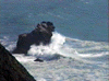
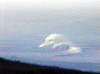
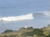 12 foot swell from the Gulf of Alaska broke far from shore.
Links to related images: Nearby. Proofs. Map.
Approximate location: 39.9418563842773N / 123.966377258301W.
 I found a message in a bottle!
Links to related images: Nearby. Proofs. Map.
Approximate location: 39.9455413818359N / 123.968612670898W.
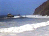
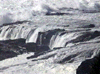
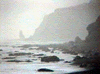
 Even protected Bear Harbor was rough with even rougher waves offshore.
Links to related images: Nearby. Proofs. Map.
Approximate location: 39.913028717041N / 123.938316345215W.
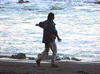
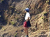 Sami Iwata was the only BASKer who came came despite the weather.
Links to related images: Nearby. Proofs. Map.
Approximate location: 39.9129638671875N / 123.938743591309W.
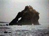
 Morgan Rock had waves breaking around it and blasting through the arch.
Links to related images: Nearby. Proofs. Map.
Approximate location: 39.9181632995605N / 123.945693969727W.

 The Cluster Cone rocks looked impossible to navigate through.
Links to related images: Nearby. Proofs. Map.
Approximate location: 39.9127655029297N / 123.938827514648W.
 Morgan Rock had waves breaking around it and blasting through the arch.
Links to related images: Nearby. Proofs. Map.
Approximate location: 39.9177665710449N / 123.945182800293W.
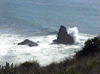 North Rock also has waves breaking around it.
Links to related images: Nearby. Proofs. Map.
Approximate location: 39.9187545776367N / 123.947151184082W.
 Morgan Rock had waves breaking around it and blasting through the arch.
Links to related images: Nearby. Proofs. Map.
Approximate location: 39.9177665710449N / 123.945182800293W.
 Last trip here, I paddled between the last two flat rocks offshore from
Flat Ro
Last trip here, I paddled between the last two flat rocks offshore from
Flat Ro
Links to related images: Nearby. Proofs. Map.
Approximate location: 39.919017791748N / 123.947242736816W.
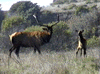
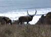
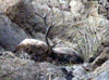
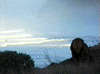
 Everywhere we went we saw huge Roosevelt's elk, including these large intimidat
Links to related images: Nearby. Proofs. Map.
Approximate location: 39.9247436523438N / 123.954879760742W.
 Several creeks flowed into the beach and disapeared into the sand. As the
water
Several creeks flowed into the beach and disapeared into the sand. As the
water
Links to related images: Nearby. Proofs. Map.
Approximate location: 39.9441604614258N / 123.967834472656W.

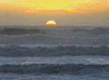 We went for a walk from one campground to another at low tide around sunset.
Links to related images: Nearby. Proofs. Map.
Approximate location: 39.9434356689453N / 123.967323303223W.
 Sami did a little dance to try and make a pelikin fly in front of the sunset
to
Sami did a little dance to try and make a pelikin fly in front of the sunset
to
Links to related images: Nearby. Proofs. Map.
Approximate location: 39.9431076049805N / 123.966979980469W.
 Needle Rock viewed through several of its arches.
Links to related images: Nearby. Proofs. Map.
Approximate location: 39.9427795410156N / 123.966979980469W.
 This tall thin rock was near our destination, the access to the next campground
Links to related images: Nearby. Proofs. Map.
Approximate location: 39.9460678100586N / 123.969123840332W.
 Everywhere we went we saw huge Roosevelt's elk, including these large intimidat
Links to related images: Nearby. Proofs. Map.
Approximate location: 39.9454116821289N / 123.968612670898W.
 Needle Rock viewed through several of its arches.
Links to related images: Nearby. Proofs. Map.
Approximate location: 39.9446220397949N / 123.968269348145W.
 This tall thin rock was near our destination, the access to the next campground
Links to related images: Nearby. Proofs. Map.
Approximate location: 39.9463310241699N / 123.969299316406W.
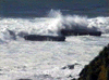
 12 foot swell from the Gulf of Alaska broke far from shore.
Links to related images: Nearby. Proofs. Map.
Approximate location: 39.9444236755371N / 123.967498779297W.
All text and images Copyright © 1997 by Mike Higgins / contact