Bodega Harbor to Miller Park, November 2nd 1997.
Click on the small image to see the full-sized one.
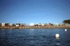 The trailer park at Lawsons Landing near Dillon Beach.
Links to related images: Nearby. Proofs. Map.
Approximate location: 38.2305946350098N / 122.967910766602W.
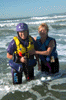 Rachel & Maryly after swimming to shore at Dillon Beach.
Links to related images: Nearby. Proofs. Map.
Approximate location: 38.2481918334961N / 122.969108581543W.
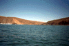
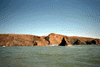
 Cloud City, the expensive homes above the cliff at Dillon Beach.
Links to related images: Nearby. Proofs. Map.
Approximate location: 38.2550659179688N / 122.973403930664W.
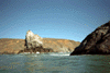
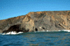
 The mouth of Estero de San Antonio.
Links to related images: Nearby. Proofs. Map.
Approximate location: 38.2674331665039N / 122.981643676758W.
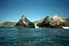
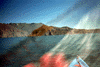
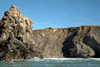
 Rocks north of Dillon Beach.
Links to related images: Nearby. Proofs. Map.
Approximate location: 38.2626495361328N / 122.978507995605W.
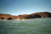
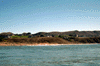
 The mouth of Estero de Americano.
Links to related images: Nearby. Proofs. Map.
Approximate location: 38.2955284118652N / 123.008422851562W.
 Roger Lamb crashed ashore near Estero de Americano.
Links to related images: Nearby. Proofs. Map.
Approximate location: 38.2998390197754N / 123.012672424316W.
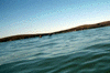
 Wave like the one that surfed Roger ashore at Estero de Americano.
Links to related images: Nearby. Proofs. Map.
Approximate location: 38.2998390197754N / 123.012672424316W.
 BASK kayakers on Bodega Bay.
Links to related images: Nearby. Proofs. Map.
Approximate location: 38.3064002990723N / 123.03800201416W.
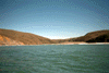
 Doran Beach from Bodega Bay.
Links to related images: Nearby. Proofs. Map.
Approximate location: 38.3060035705566N / 123.045417785645W.
All text and images Copyright © 1997 by Mike Higgins / contact