Mike's Kayak Journal, all photos taken on 1998-01-13
Click on the small image to see the full-sized one.
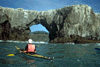
 Hans considers Goat Rock Arch
Links to related images: Nearby. Proofs. Map.
Approximate location: 38.4324989318848N / 123.126998901367W.
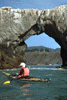
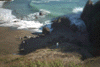
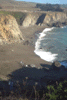
 Duncans Point with receeding wave
Links to related images: Nearby. Proofs. Map.
Approximate location: 38.394416809082N / 123.09700012207W.
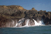
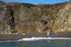
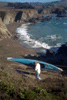
 Roger Lamb in front of Duncans Point
Links to related images: Nearby. Proofs. Map.
Approximate location: 38.394416809082N / 123.09700012207W.
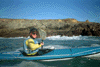
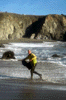
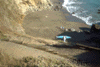
 Roger Lamb landed on Duncans Landing
Links to related images: Nearby. Proofs. Map.
Approximate location: 38.3942794799805N / 123.093139648438W.
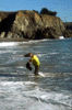
 Roger Lamb swims at Duncans Landing
Links to related images: Nearby. Proofs. Map.
Approximate location: 38.3942794799805N / 123.093482971191W.
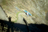
 Roger on zig-zag trail, fuzzy
Links to related images: Nearby. Proofs. Map.
Approximate location: 38.3944816589355N / 123.094253540039W.
 Roger Lamb starts up trail with boat
Links to related images: Nearby. Proofs. Map.
Approximate location: 38.3944816589355N / 123.094253540039W.
 Into the shadows
Links to related images: Nearby. Proofs. Map.
Approximate location: 38.3944816589355N / 123.094253540039W.
 Back into bright light
Links to related images: Nearby. Proofs. Map.
Approximate location: 38.3944816589355N / 123.094253540039W.
 Almost to the top!
Links to related images: Nearby. Proofs. Map.
Approximate location: 38.3944816589355N / 123.094253540039W.
All text and images Copyright © 1998 by Mike Higgins / contact