Lakeville to China Camp, February 22nd 1998.
Click on the small image to see the full-sized one.
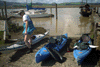 preparing to launch at Lakeville Marina
Links to related images: Nearby. Map.
Approximate location: 38.1973991394043N / 122.54744720459W.
 Bill Steiger in fron of Chinese junk
Links to related images: Nearby. Map.
Approximate location: 38.1972122192383N / 122.547660827637W.
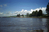
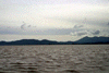
 kayakers and big sky on Petaluma River
Links to related images: Nearby. Map.
Approximate location: 38.1942443847656N / 122.546951293945W.
 east bank of Petaluma River
Links to related images: Nearby. Proofs. Map.
Approximate location: 38.1447334289551N / 122.525367736816W.
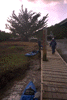 stop at pier for lunch
Links to related images: Nearby. Proofs. Map.
Approximate location: 38.1145706176758N / 122.506164550781W.
 Bill starting out into San Pablo Bay
Links to related images: Nearby. Proofs. Map.
Approximate location: 38.1087112426758N / 122.48755645752W.
 Boat in channel in San Pablo Bay
Links to related images: Nearby. Proofs. Map.
Approximate location: 38.1012001037598N / 122.479362487793W.
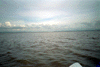
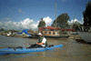
 Not much to see on big muddy San Pablo Bay
Links to related images: Nearby. Proofs. Map.
Approximate location: 38.0791778564453N / 122.475074768066W.
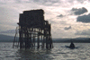
 Our first Duck Blind on San Pablo Bay
Links to related images: Nearby. Map.
Approximate location: 38.0429039001465N / 122.494659423828W.
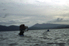
 kayaker and duck blind backlit
Links to related images: Nearby. Map.
Approximate location: 38.0391006469727N / 122.495895385742W.
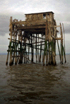 Indigenous looking duck blind
Links to related images: Nearby. Map.
Approximate location: 38.0389976501465N / 122.495834350586W.
All text and images Copyright © 1998 by Mike Higgins / contact