Baja, Sunday April 12th 1998.
Click on the small image to see the full-sized one.
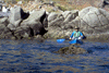
 Everywhere we went we saw many pelicans.
Links to related images: Nearby. Proofs. Map.
Approximate location: 29.595401763916N / 114.041519165039W.
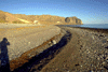
 El Muertito fishing village was just a few shacks at one end of a beach.
The on
El Muertito fishing village was just a few shacks at one end of a beach.
The on
Links to related images: Nearby. Proofs. Map.
Approximate location: 29.4144992828369N / 113.787002563477W.
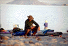
 Penny unloading on another beautiful gravel beach
Links to related images: Nearby. Proofs. Map.
Approximate location: 29.4122009277344N / 113.779998779297W.
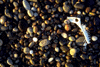
 Footprints on a gravel beach
Links to related images: Nearby. Proofs. Map.
Approximate location: 29.4122009277344N / 113.779998779297W.
 El Muertito fishing village was just a few shacks at one end of a beach.
Links to related images: Nearby. Proofs. Map.
Approximate location: 29.4122009277344N / 113.779998779297W.
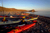
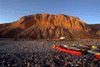 Evening light on cobble, kayaks, tents and bluff
Links to related images: Nearby. Proofs. Map.
Approximate location: 29.4122009277344N / 113.779998779297W.
 Evening light on kayaks on gravel beach
Links to related images: Nearby. Proofs. Map.
Approximate location: 29.4122009277344N / 113.779998779297W.
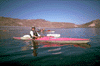
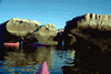
 The intrepid kayaker in calm water on the rugged baja shoreline
Links to related images: Nearby. Proofs. Map.
Approximate location: 29.0666999816895N / 113.525001525879W.
 Penny and I in the Ship Rocks
Links to related images: Nearby. Proofs. Map.
Approximate location: 29.0666999816895N / 113.525001525879W.
 The intrepid kayaker in front of a Baja cobble beach
Links to related images: Nearby. Proofs. Map.
Approximate location: 29.0666999816895N / 113.525001525879W.
 The relaxing kayaker reading a book at camp in Baja
Links to related images: Nearby. Proofs. Map.
Approximate location: 29.1916999816895N / 113.633003234863W.
All text and images Copyright © 1998 by Mike Higgins / contact