Baja, Isla Alcatraz Thursday April 16th 1998.
Click on the small image to see the full-sized one.
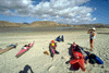
 Packing up for our last day of paddling.
Links to related images: Nearby. Proofs. Map.
Approximate location: 29.1916999816895N / 113.633003234863W.
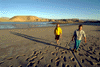
 Here we all are after making it safely to La Gringa beach.
Links to related images: Nearby. Proofs. Map.
Approximate location: 29.0666999816895N / 113.525001525879W.
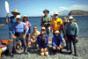
 Everyone posing at the end of the trip
Links to related images: Nearby. Proofs. Map.
Approximate location: 29.0666999816895N / 113.525001525879W.
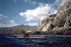 Jean paddling in front of rugged Baja shoreline
Links to related images: Nearby. Proofs. Map.
Approximate location: 29.0666999816895N / 113.525001525879W.
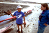
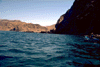 Me in blue water in front of rugged Baja shoreline
Links to related images: Nearby. Proofs. Map.
Approximate location: 29.0666999816895N / 113.525001525879W.
All text and images Copyright © 1998 by Mike Higgins / contact