Kayak Camping, September 14th to 17th 1998.
Click on the small image to see the full-sized one.
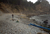
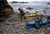
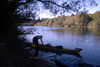
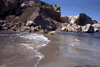
 Packing up to leave from the private boat ramp at Ocean Cove.
Links to related images: Nearby. Proofs. Map.
Approximate location: 38.5554161071777N / 123.303504943848W.
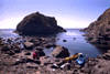
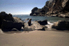
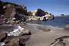
 Ken Kelton and I stop at Fisk Mill cove while on a
kayak camping trip.
Ken Kelton and I stop at Fisk Mill cove while on a
kayak camping trip.
Links to related images: Nearby. Proofs. Map.
Approximate location: 38.5964126586914N / 123.349082946777W.
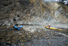
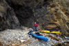
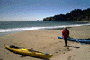
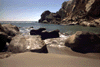
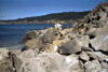
 Ken Kelton and I stop at Rocky Point while on a
kayak camping trip.
Ken Kelton and I stop at Rocky Point while on a
kayak camping trip.
Links to related images: Nearby. Proofs. Map.
Approximate location: 38.6365165710449N / 123.393463134766W.
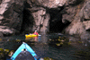
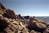
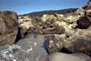
 Ken and I 'ninja camping' near Stuarts Point in a crack in the cliff
Links to related images: Nearby. Proofs. Map.
Approximate location: 38.6529006958008N / 123.40599822998W.
 Ken and I paddled up the Gualala River to the campground.
Links to related images: Nearby. Proofs. Map.
Approximate location: 38.7640991210938N / 123.516998291016W.
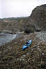
 With Ken Kelton, I stopped at beautiful Bourns Landing for lunch.
Links to related images: Nearby. Proofs. Map.
Approximate location: 38.785099029541N / 123.559997558594W.
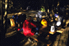
 That evening we camped at the Anchor Bay Campground.
Links to related images: Nearby. Proofs. Map.
Approximate location: 38.80419921875N / 123.580001831055W.

 with Ken Kelton, we stopped at Steens Landing for lunch.
Links to related images: Nearby. Proofs. Map.
Approximate location: 38.828498840332N / 123.61799621582W.
 Looking south from Steens Landing
Links to related images: Nearby. Proofs. Map.
Approximate location: 38.828498840332N / 123.61799621582W.
 Ken, his boat and the stone wall at Steens Landing
Links to related images: Nearby. Proofs. Map.
Approximate location: 38.828498840332N / 123.61799621582W.
 The next day I landed to take pictures of the sea lions while Ken surfed across
Links to related images: Nearby. Proofs. Map.
Approximate location: 38.7999000549316N / 123.592002868652W.
 Ken surfing the sand between the Fish Rock Islands
Links to related images: Nearby. Proofs. Map.
Approximate location: 38.7999000549316N / 123.592002868652W.
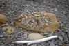
 Close up of east Fish Rock
Links to related images: Nearby. Proofs. Map.
Approximate location: 38.7999000549316N / 123.592002868652W.
 Ken approaching the spit between the Fish Rocks
Links to related images: Nearby. Proofs. Map.
Approximate location: 38.799934387207N / 123.592437744141W.
 Close up of east Fish Rock
Links to related images: Nearby. Proofs. Map.
Approximate location: 38.799934387207N / 123.592437744141W.
 California sea lion sleeping right above my kayak on east Fish Rock!
Links to related images: Nearby. Proofs. Map.
Approximate location: 38.799934387207N / 123.592437744141W.
All text and images Copyright © 1998 by Mike Higgins / contact