Lost Coast Campout, October 9th - 12th 1998.
Click on the small image to see the full-sized one.
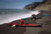
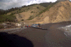
 Folding boats launching at Usal Beach
Links to related images: Nearby. Proofs. Map.
Approximate location: 39.8321380615234N / 123.85205078125W.

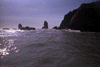 Approaching the end of our afternoon paddle.
Links to related images: Nearby. Proofs. Map.
Approximate location: 39.9115142822266N / 123.938484191895W.
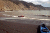
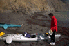
 Landing in the protected waters at Bear Harbor requires landing at high tide
wh
Landing in the protected waters at Bear Harbor requires landing at high tide
wh
Links to related images: Nearby. Proofs. Map.
Approximate location: 39.9130935668945N / 123.938140869141W.
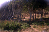
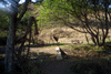

 Elk in my favorite campground at Bear Harbor
Links to related images: Nearby. Proofs. Map.
Approximate location: 39.9133567810059N / 123.938484191895W.
 Landing in the protected waters at Bear Harbor requires landing at high tide
wh
Landing in the protected waters at Bear Harbor requires landing at high tide
wh
Links to related images: Nearby. Proofs. Map.
Approximate location: 39.913028717041N / 123.93822479248W.
 Charles and Brian were two of the kayakers who drove in to meet us.
Links to related images: Nearby. Proofs. Map.
Approximate location: 39.9143447875977N / 123.939170837402W.

 When we arrived we found my favorite campsite was claimed by a large
bull elk a
When we arrived we found my favorite campsite was claimed by a large
bull elk a
Links to related images: Nearby. Proofs. Map.
Approximate location: 39.9132919311523N / 123.938140869141W.
 Charles and Brian were two of the kayakers who drove in to meet us.
Links to related images: Nearby. Proofs. Map.
Approximate location: 39.9129638671875N / 123.938056945801W.
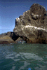
 Roger Lamb and I played around the Cluster Cone Rocks and through Morgan Rock (
Links to related images: Nearby. Proofs. Map.
Approximate location: 39.9112510681152N / 123.940544128418W.
 On Saturday we paddled north past the Needle Rock Visitors Center but
made our
On Saturday we paddled north past the Needle Rock Visitors Center but
made our
Links to related images: Nearby. Proofs. Map.
Approximate location: 39.9396858215332N / 123.967834472656W.
 On Sunday we paddled south to the Anderson Cliffs (in the distance)
and landed
On Sunday we paddled south to the Anderson Cliffs (in the distance)
and landed
Links to related images: Nearby. Proofs. Map.
Approximate location: 39.9088134765625N / 123.934280395508W.
 Roger Lamb and I played around the Cluster Cone Rocks and through Morgan Rock (
Links to related images: Nearby. Proofs. Map.
Approximate location: 39.9165840148926N / 123.947494506836W.
 If you land at low tide the water exposes rocks to bang up kayaks.
Links to related images: Nearby. Proofs. Map.
Approximate location: 39.9129638671875N / 123.937797546387W.
 Roger Lamb and I played around the Cluster Cone Rocks and through Morgan Rock (
Links to related images: Nearby. Proofs. Map.
Approximate location: 39.9166488647461N / 123.947326660156W.
 On Sunday we paddled south to the Anderson Cliffs (in the distance)
and landed
On Sunday we paddled south to the Anderson Cliffs (in the distance)
and landed
Links to related images: Nearby. Proofs. Map.
Approximate location: 39.8904418945312N / 123.920372009277W.
 The waves were calm enough to land near Anderson Cliffs
Links to related images: Nearby. Proofs. Map.
Approximate location: 39.8904418945312N / 123.920372009277W.
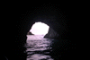
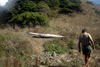
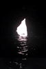 On the trip home Sunday afternoon I went through every cave and arch!
Links to related images: Nearby. Proofs. Map.
Approximate location: 39.8751640319824N / 123.914962768555W.
All text and images Copyright © 1998 by Mike Higgins / contact