Carquinez Strait, Sunday November 8th 1998.
Click on the small image to see the full-sized one.
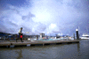

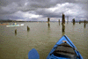
 Launching from the Martinez ramp and paddling west on the Carquinez Strait.
Links to related images: Nearby. Proofs. Map.
Approximate location: 38.0384254455566N / 122.172004699707W.
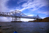

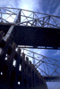
 The Carquinez Bridge does have an engineering elligance to it.
Links to related images: Nearby. Proofs. Map.
Approximate location: 38.0613899230957N / 122.22534942627W.
 Allthough not one of the Bay Areas most attractive bridges, the Carquinez
Bridg
Allthough not one of the Bay Areas most attractive bridges, the Carquinez
Bridg
Links to related images: Nearby. Proofs. Map.
Approximate location: 38.0613899230957N / 122.22534942627W.

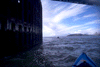
 We discovered that a kayaker can paddle inside the central pylon that
holds up
We discovered that a kayaker can paddle inside the central pylon that
holds up
Links to related images: Nearby. Proofs. Map.
Approximate location: 38.0610847473145N / 122.225387573242W.
 Allthough not one of the Bay Areas most attractive bridges, the Carquinez
Bridg
Allthough not one of the Bay Areas most attractive bridges, the Carquinez
Bridg
Links to related images: Nearby. Proofs. Map.
Approximate location: 38.0610847473145N / 122.225387573242W.


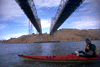
 We discovered that a kayaker can paddle inside the central pylon that
holds up
We discovered that a kayaker can paddle inside the central pylon that
holds up
Links to related images: Nearby. Proofs. Map.
Approximate location: 38.0609817504883N / 122.22599029541W.
 Allthough not one of the Bay Areas most attractive bridges, the Carquinez
Bridg
Allthough not one of the Bay Areas most attractive bridges, the Carquinez
Bridg
Links to related images: Nearby. Proofs. Map.
Approximate location: 38.0637702941895N / 122.224403381348W.
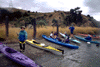
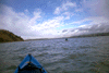
 On the way home we stopped for lunch.
Links to related images: Nearby. Proofs. Map.
Approximate location: 38.0361175537109N / 122.173301696777W.
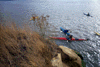
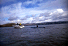
 Across the Carquinez Strait from Martinez is a little island where
a lone kayak
Across the Carquinez Strait from Martinez is a little island where
a lone kayak
Links to related images: Nearby. Proofs. Map.
Approximate location: 38.0436058044434N / 122.166152954102W.
All text and images Copyright © 1998 by Mike Higgins / contact