Running the Mighty Austin Creek, March 16th 1999.
Click on the small image to see the full-sized one.
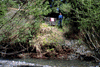 Ken Mannshardt's dad and cabin
Links to related images: Nearby.
Approximate location: 38.5220489501953N / 123.084465026855W.
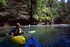
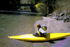 Ken getting in his boat
Links to related images: Nearby.
Approximate location: 38.5220489501953N / 123.084465026855W.
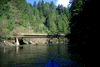
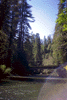 Austin Creek bridge
Links to related images: Nearby.
Approximate location: 38.5199661254883N / 123.08472442627W.
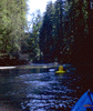
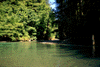
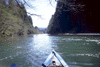
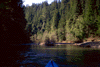 Beautiful Austin Creek
Links to related images: Nearby.
Approximate location: 38.5133171081543N / 123.077003479004W.
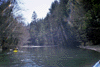
 Ken drifting sideways
Links to related images: Nearby.
Approximate location: 38.5103645324707N / 123.071594238281W.
 Rainbow beams of sunlight
Links to related images: Nearby.
Approximate location: 38.509220123291N / 123.069274902344W.
 sunny bend in river
Links to related images: Nearby.
Approximate location: 38.5106315612793N / 123.074768066406W.
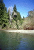
 house on gravely bank
Links to related images: Nearby.
Approximate location: 38.5115051269531N / 123.073394775391W.
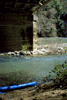
 Ken under Austin Creek bridge
Links to related images: Nearby.
Approximate location: 38.5104293823242N / 123.070304870605W.
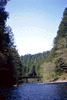
 East Fork of Austin Creek
Links to related images: Nearby.
Approximate location: 38.5094223022461N / 123.068161010742W.
 another austin creek bridge
Links to related images: Nearby. Proofs. Map.
Approximate location: 38.5062675476074N / 123.069358825684W.
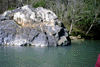 Big rock in austin creek
Links to related images: Nearby. Proofs. Map.
Approximate location: 38.496997833252N / 123.068244934082W.
 long straight stretch
Links to related images: Nearby. Proofs. Map.
Approximate location: 38.4810752868652N / 123.052627563477W.
 Under the railroad bridge
Links to related images: Nearby. Proofs. Map.
Approximate location: 38.4672317504883N / 123.049194335938W.
All text and images Copyright © 1999 by Mike Higgins / contact