Baja, Sierra Agua de Soda to Bahia San Rafael, April 23nd 2000.
Click on the small image to see the full-sized one.
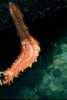 Strange Sea Creature, fuzzy picture
Links to related images: Nearby. Proofs. Map.
Approximate location: 28.7023334503174N / 113.173683166504W.
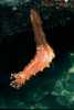 Strange Sea Creature, good picture!
Links to related images: Nearby. Proofs. Map.
Approximate location: 28.7023334503174N / 113.173683166504W.
 Kayaks on other side of tide rip
Links to related images: Nearby. Proofs. Map.
Approximate location: 28.6309394836426N / 113.125877380371W.
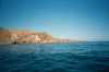
 Rocky cliff
Links to related images: Nearby. Proofs. Map.
Approximate location: 28.6242332458496N / 113.127510070801W.
 Maryly in rock garden
Links to related images: Nearby. Proofs. Map.
Approximate location: 28.6206932067871N / 113.128799438477W.
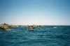
 Kayakers on Lunch Beach
Links to related images: Nearby. Proofs. Map.
Approximate location: 28.5905513763428N / 113.127593994141W.
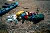 All the gear out of my boat
Links to related images: Nearby. Proofs. Map.
Approximate location: 28.5208911895752N / 113.110771179199W.
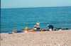
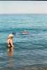 Kayakers bathing
Links to related images: Nearby. Proofs. Map.
Approximate location: 28.5208911895752N / 113.110771179199W.
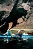 Kayakers in front of arch
Links to related images: Nearby. Proofs. Map.
Approximate location: 28.5628128051758N / 113.115921020508W.
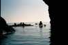 Picture back out of arch
Links to related images: Nearby. Proofs. Map.
Approximate location: 28.5628128051758N / 113.115921020508W.
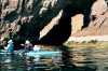
 Mike Chin inside arch/cave
Links to related images: Nearby. Proofs. Map.
Approximate location: 28.5628128051758N / 113.115921020508W.
 Andy kayaking in front of long beach
Links to related images: Nearby. Proofs. Map.
Approximate location: 28.5934143066406N / 113.128280639648W.
 Looking back where we had been
Links to related images: Nearby. Proofs. Map.
Approximate location: 28.5921001434326N / 113.126998901367W.
All text and images Copyright © 2000 by Mike Higgins / contact