Baja, San Franciscito Resort, April 27th 2000.
Click on the small image to see the full-sized one.
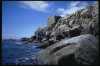
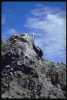
 Rocky shore
Links to related images: Nearby. Proofs. Map.
Approximate location: 28.440845489502N / 112.846412658691W.
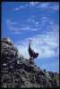
 pelican up close
Links to related images: Nearby. Proofs. Map.
Approximate location: 28.4399394989014N / 112.845985412598W.
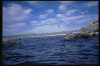 Sandy beach ahead
Links to related images: Nearby. Proofs. Map.
Approximate location: 28.4219760894775N / 112.844093322754W.
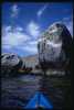
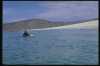 Andy approaching Encenada Blanca
Links to related images: Nearby. Proofs. Map.
Approximate location: 28.4154090881348N / 112.851737976074W.
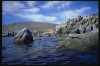
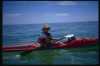 Maryly in calm green water
Links to related images: Nearby. Proofs. Map.
Approximate location: 28.4143524169922N / 112.853790283203W.
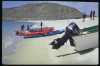 Landed at San Franciscito
Links to related images: Nearby. Proofs. Map.
Approximate location: 28.4090671539307N / 112.857696533203W.
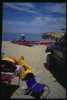 Car camping at San Franciscito
Links to related images: Nearby. Proofs. Map.
Approximate location: 28.4101047515869N / 112.857681274414W.
All text and images Copyright © 2000 by Mike Higgins / contact