Baja, Santa Ynes to Isla San Louis, April 14th 2001.
Click on the small image to see the full-sized one.
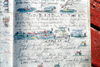 The log entry from my last trip past Coco's Corner
Links to related images: Nearby.
Approximate location: 29.5197696685791N / 114.294204711914W.
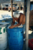 Coco at Coco's Corner
Links to related images: Nearby.
Approximate location: 29.5197696685791N / 114.294204711914W.
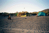
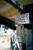 An art instalation at Coco's Corner
Links to related images: Nearby.
Approximate location: 29.5197696685791N / 114.294204711914W.
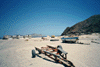 Would you leave your car parked here at Punta Bufeo?
Links to related images: Nearby. Proofs. Map.
Approximate location: 29.9055442810059N / 114.442779541016W.
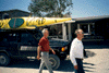 Konstantin and Sid Taylor at Punta Bufeo
Links to related images: Nearby. Proofs. Map.
Approximate location: 29.9055442810059N / 114.442779541016W.
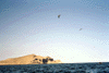
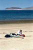 Packing up with views of Isla San Louis
Links to related images: Nearby. Proofs. Map.
Approximate location: 29.9074039459229N / 114.441833496094W.
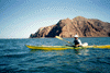 Konstantin with Punto Bufeo behind
Links to related images: Nearby. Proofs. Map.
Approximate location: 29.9147701263428N / 114.438232421875W.
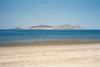
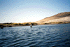
 Approaching Isla San Louis
Links to related images: Nearby. Proofs. Map.
Approximate location: 29.9354496002197N / 114.420372009277W.
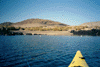
 A cove we considered landing in
Links to related images: Nearby. Proofs. Map.
Approximate location: 29.9654197692871N / 114.419090270996W.
 A cove we considered landing in
Links to related images: Nearby. Proofs. Map.
Approximate location: 29.9654197692871N / 114.419090270996W.
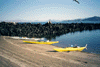
 Our camp on Isla San Louis
Links to related images: Nearby. Proofs. Map.
Approximate location: 29.962890625N / 114.41780090332W.
All text and images Copyright © 2001 by Mike Higgins / contact