Andrew Molera to McWay Cove, August 12th 2001.
Click on the small image to see the full-sized one.
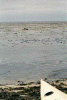
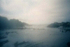
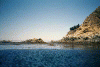
 Kelp fields and seals off our campsite
Links to related images: Nearby. Proofs. Map.
Approximate location: 36.2909851074219N / 121.877258300781W.
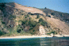
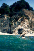
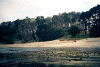 Where we should have camped!
Links to related images: Nearby. Proofs. Map.
Approximate location: 36.2878036499023N / 121.872535705566W.
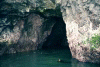
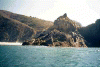
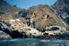
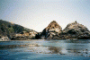
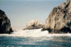
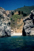
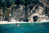
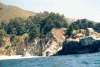
 Caves in the next point
Links to related images: Nearby. Proofs. Map.
Approximate location: 36.2817153930664N / 121.863868713379W.
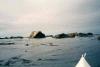
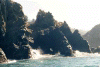
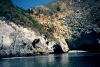
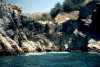
 fuzzy rock garden
Links to related images: Nearby. Proofs. Map.
Approximate location: 36.2817153930664N / 121.863868713379W.
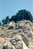
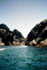
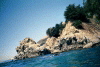
 rock garden off Andrew Molera
Links to related images: Nearby. Proofs. Map.
Approximate location: 36.2806739807129N / 121.863525390625W.
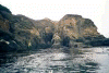
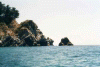
 Andrew Molera point
Links to related images: Nearby. Proofs. Map.
Approximate location: 36.27880859375N / 121.859580993652W.
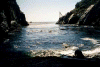
 sur point behind us
Links to related images: Nearby. Proofs. Map.
Approximate location: 36.277702331543N / 121.860008239746W.
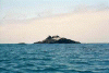 offshore rock
Links to related images: Nearby. Proofs. Map.
Approximate location: 36.262336730957N / 121.843353271484W.


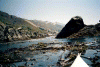
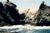
 cooper point
Links to related images: Nearby.
Approximate location: 36.2450332641602N / 121.834091186523W.


 Pfeifer Rocks and beach
Links to related images: Nearby.
Approximate location: 36.2359657287598N / 121.816917419434W.
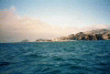
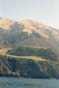
 Big Sur coastline
Links to related images: Nearby.
Approximate location: 36.230842590332N / 121.805847167969W.
 view back to Pfeifer Beach
Links to related images: Nearby.
Approximate location: 36.230842590332N / 121.805847167969W.
 Pastorial big sur farm
Links to related images: Nearby.
Approximate location: 36.217342376709N / 121.769973754883W.
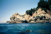
 seal sleeping on water
Links to related images: Nearby.
Approximate location: 36.2147102355957N / 121.765853881836W.
 seal waking up fast!
Links to related images: Nearby.
Approximate location: 36.2147102355957N / 121.765853881836W.
 House on rocky point
Links to related images: Nearby.
Approximate location: 36.208683013916N / 121.754951477051W.
 house on rocky point
Links to related images: Nearby.
Approximate location: 36.208683013916N / 121.754951477051W.
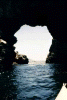
 first knotch in Partington Point
Links to related images: Nearby. Proofs. Map.
Approximate location: 36.2039070129395N / 121.738555908203W.
 View out knotch in Partington Point
Links to related images: Nearby. Proofs. Map.
Approximate location: 36.2039070129395N / 121.738555908203W.
 Doghole framework on Partington Point
Links to related images: Nearby. Proofs. Map.
Approximate location: 36.2036972045898N / 121.737266540527W.
 second knotch in Partington Point, view in
Links to related images: Nearby. Proofs. Map.
Approximate location: 36.2036972045898N / 121.737266540527W.
 View out from landing at Partington Point
Links to related images: Nearby. Proofs. Map.
Approximate location: 36.2036972045898N / 121.737266540527W.
 Doghole remains at partington point
Links to related images: Nearby. Proofs. Map.
Approximate location: 36.2036972045898N / 121.737266540527W.
 Thick kelp Anderson Landing
Links to related images: Nearby. Proofs. Map.
Approximate location: 36.1998901367188N / 121.731002807617W.
 Looking N nea Anderson Landing
Links to related images: Nearby. Proofs. Map.
Approximate location: 36.1987113952637N / 121.727485656738W.
 Looking N nearAnderson Landing
Links to related images: Nearby. Proofs. Map.
Approximate location: 36.1987113952637N / 121.727485656738W.
 More thick kelp, rocky shore
Links to related images: Nearby. Proofs. Map.
Approximate location: 36.1987113952637N / 121.727485656738W.
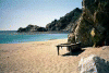
 First view of sandy beach in McWay Cove
Links to related images: Nearby. Proofs. Map.
Approximate location: 36.1649742126465N / 121.683029174805W.
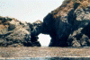
 Arch in McWay Rocks
Links to related images: Nearby. Proofs. Map.
Approximate location: 36.163932800293N / 121.680793762207W.
 View back out of McWay Cove
Links to related images: Nearby. Proofs. Map.
Approximate location: 36.163932800293N / 121.680793762207W.
 McWay arch closer
Links to related images: Nearby. Proofs. Map.
Approximate location: 36.1633796691895N / 121.679420471191W.
 White water between the McWay Rocks
Links to related images: Nearby. Proofs. Map.
Approximate location: 36.1628265380859N / 121.679336547852W.
 McWay arch up close with Konstantin framed
Links to related images: Nearby. Proofs. Map.
Approximate location: 36.1625480651855N / 121.679679870605W.
 Looking S from McWay Rocks
Links to related images: Nearby. Proofs. Map.
Approximate location: 36.1617164611816N / 121.678993225098W.
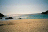
 Sandy beach between McWay Rocks
Links to related images: Nearby. Proofs. Map.
Approximate location: 36.1617164611816N / 121.678993225098W.
 Rock Garden S of McWay Cove
Links to related images: Nearby. Proofs. Map.
Approximate location: 36.1604690551758N / 121.675643920898W.
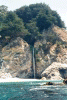
 Waterfall at Julia Pfeifer Burns State Park
Links to related images: Nearby. Proofs. Map.
Approximate location: 36.140022277832N / 121.654357910156W.

 Rocks south of Julia Park
Links to related images: Nearby. Proofs. Map.
Approximate location: 36.1381530761719N / 121.653587341309W.
 Me in front of waterfall
Links to related images: Nearby. Proofs. Map.
Approximate location: 36.1399536132812N / 121.65478515625W.
 The intrepid kayaker in front of the Big Sur waterfall
Links to related images: Nearby. Proofs. Map.
Approximate location: 36.1399536132812N / 121.65478515625W.
 More rock gardening S of waterfall
Links to related images: Nearby. Proofs. Map.
Approximate location: 36.1399536132812N / 121.65478515625W.
 Waterfall from a distance
Links to related images: Nearby. Proofs. Map.
Approximate location: 36.1399536132812N / 121.65478515625W.
 McWay rocks and cove on our way back
Links to related images: Nearby. Proofs. Map.
Approximate location: 36.1592903137207N / 121.676414489746W.
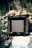 Storage locker on beach at McWay
Links to related images: Nearby. Proofs. Map.
Approximate location: 36.1631698608398N / 121.677101135254W.
 Panorama of McWay Beach, 1/4
Links to related images: Nearby. Proofs. Map.
Approximate location: 36.1631698608398N / 121.677101135254W.
 Panorama of McWay Beach, 2/4
Links to related images: Nearby. Proofs. Map.
Approximate location: 36.1631698608398N / 121.677101135254W.
 Panorama of McWay Beach, 3/4
Links to related images: Nearby. Proofs. Map.
Approximate location: 36.1631698608398N / 121.677101135254W.
 Panorama of McWay Beach, 4/4
Links to related images: Nearby. Proofs. Map.
Approximate location: 36.1631698608398N / 121.677101135254W.
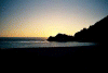 McWay Beach Sunset
Links to related images: Nearby. Proofs. Map.
Approximate location: 36.1631698608398N / 121.677101135254W.
All text and images Copyright © 2001 by Mike Higgins / contact