McWay Cove to Gorda Point, August 13th 2001.
Click on the small image to see the full-sized one.
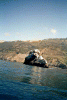
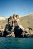
 Arch south of McWay Cove
Links to related images: Nearby. Proofs. Map.
Approximate location: 36.1599159240723N / 121.674446105957W.
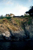 Big Sur house on cliff
Links to related images: Nearby. Proofs. Map.
Approximate location: 36.158390045166N / 121.674011230469W.
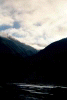
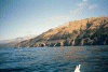
 View north, fog bank on cliftop
Links to related images: Nearby. Proofs. Map.
Approximate location: 36.1581115722656N / 121.674530029297W.
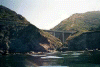
 Big Sur bridge, kelp bed
Links to related images: Nearby. Proofs. Map.
Approximate location: 36.153678894043N / 121.66877746582W.
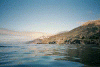
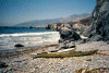
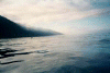 Beautiful water on calm day
Links to related images: Nearby. Proofs. Map.
Approximate location: 36.1489639282227N / 121.66877746582W.
 Big sur house near water
Links to related images: Nearby. Proofs. Map.
Approximate location: 36.140926361084N / 121.658821105957W.
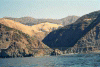
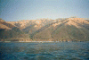
 View up Big Sur Valley
Links to related images: Nearby. Proofs. Map.
Approximate location: 36.1301116943359N / 121.651611328125W.
 Square Black Rock from north
Links to related images: Nearby. Proofs. Map.
Approximate location: 36.1240119934082N / 121.646118164062W.
 Square Black Rock from south
Links to related images: Nearby. Proofs. Map.
Approximate location: 36.119987487793N / 121.635650634766W.
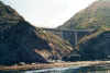
 Old fashoned Big Sur Bridge
Links to related images: Nearby. Proofs. Map.
Approximate location: 36.1117362976074N / 121.631782531738W.
 New fashoned Big Sur Bridge
Links to related images: Nearby. Proofs. Map.
Approximate location: 36.1117362976074N / 121.631782531738W.
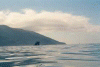
 Lopez Rock and Point
Links to related images: Nearby. Proofs. Map.
Approximate location: 36.0177268981934N / 121.566299438477W.
 Beautiful water and fog looking north
Links to related images: Nearby. Proofs. Map.
Approximate location: 36.0202941894531N / 121.573165893555W.
 Lopez Rock up close
Links to related images: Nearby. Proofs. Map.
Approximate location: 36.0183525085449N / 121.569732666016W.
 Lime Kiln State Park
Links to related images: Nearby. Proofs. Map.
Approximate location: 36.0025215148926N / 121.528961181641W.
 Mill Creek State Park
Links to related images: Nearby. Proofs. Map.
Approximate location: 35.9821739196777N / 121.504837036133W.
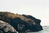
 Rock at Gorda Point
Links to related images: Nearby. Proofs. Map.
Approximate location: 35.9604301452637N / 121.487670898438W.
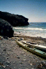
 Our campground on Gorda Point
Links to related images: Nearby. Proofs. Map.
Approximate location: 35.932430267334N / 121.474800109863W.
 Konstantin on the top of Gorda Point
Links to related images: Nearby. Proofs. Map.
Approximate location: 35.932430267334N / 121.474800109863W.
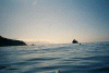
 looking south over our boats
Links to related images: Nearby. Proofs. Map.
Approximate location: 35.932430267334N / 121.474800109863W.
All text and images Copyright © 2001 by Mike Higgins / contact