Baja, Layover Day at Punta la Anita, April 1st 2002.
Click on the small image to see the full-sized one.
 Obsidian pebbles in the gravel at Punta la Anita
Links to related images: Nearby. Map.
Approximate location: 27.6192855834961N / 112.484893798828W.
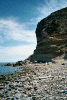 The campsite on the gravel beach at Punta la Anita
Links to related images: Nearby. Map.
Approximate location: 27.6192855834961N / 112.484893798828W.
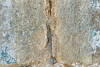 Fiberglass from wrecked boat at Punta la Anita
Links to related images: Nearby. Map.
Approximate location: 27.6192855834961N / 112.484893798828W.


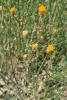
 Wildflowers in the desert at Punta la Anita
Links to related images: Nearby. Map.
Approximate location: 27.617992401123N / 112.486778259277W.
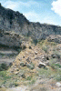
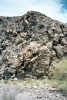 The side of the arroyo behind camp at Punta la Anita
Links to related images: Nearby. Map.
Approximate location: 27.6149501800537N / 112.491844177246W.
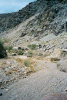


 The gravel trail up the middle of the arroyo at Punta la Anita
Links to related images: Nearby. Map.
Approximate location: 27.6156349182129N / 112.488586425781W.
All text and images Copyright © 2002 by Mike Higgins / contact