Pebble Beach to Stump Beach, July 13th 2002.
Click on the small image to see the full-sized one.
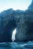

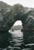
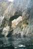
 Arches and rocks south of Pebble Beach Sea Ranch
Links to related images: Nearby. Proofs. Map.
Approximate location: 38.7000007629395N / 123.445999145508W.
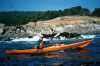
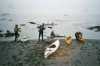 BASKers ready to launch from Pebble Beach at Sea Ranch
Links to related images: Nearby. Proofs. Map.
Approximate location: 38.7030601501465N / 123.445472717285W.
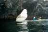
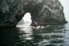
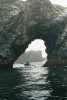
 Everyone had to go through this litle arch south of Pebble Beach Sea Ranch
Links to related images: Nearby. Proofs. Map.
Approximate location: 38.6916732788086N / 123.439895629883W.
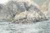
 Rocks south of Sea Ranch
Links to related images: Nearby. Proofs. Map.
Approximate location: 38.6781387329102N / 123.432167053223W.
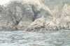
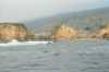
 Hole in the rock south of Sea Ranch
Links to related images: Nearby. Proofs. Map.
Approximate location: 38.6766662597656N / 123.428909301758W.
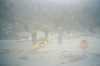 Fuzzy landing at Stewarts Point
Links to related images: Nearby. Proofs. Map.
Approximate location: 38.6546821594238N / 123.407188415527W.
 Looking back at Stewarts Point
Links to related images: Nearby. Proofs. Map.
Approximate location: 38.6518669128418N / 123.407875061035W.
 Maryly Snow south of Stewarts Point
Links to related images: Nearby. Proofs. Map.
Approximate location: 38.6444931030273N / 123.402214050293W.
All text and images Copyright © 2002 by Mike Higgins / contact