Corales to Yelapa, December 30th 2002.
Click on the small image to see the full-sized one.
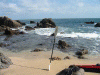
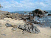
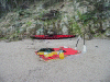 My Punta Tabito Camp after taking down the tent
Links to related images: Nearby. Proofs. Map.
Approximate location: 20.4272537231445N / 105.654403686523W.
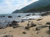
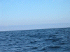 There is a whale tale in this picture (really!)
Links to related images: Nearby. Proofs. Map.
Approximate location: 20.4577350616455N / 105.629508972168W.
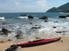
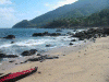
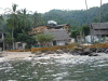
 Amelia's Beach, rocky landing for lunch
Links to related images: Nearby. Proofs. Map.
Approximate location: 20.4831447601318N / 105.573287963867W.
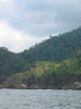 Fuzzy jungle picture from the water.
Links to related images: Nearby. Proofs. Map.
Approximate location: 20.4939994812012N / 105.518531799316W.
 My palapa behind the dock at Yelapa
Links to related images: Nearby. Proofs. Map.
Approximate location: 20.490140914917N / 105.448669433594W.
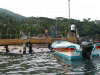 end of the Yelapa dock
Links to related images: Nearby. Proofs. Map.
Approximate location: 20.490140914917N / 105.448669433594W.
 Linda taking pictures at supper
Links to related images: Nearby. Proofs. Map.
Approximate location: 20.4896583557129N / 105.442657470703W.
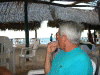 Konstantin at supper
Links to related images: Nearby. Proofs. Map.
Approximate location: 20.4896583557129N / 105.442657470703W.
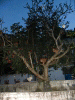 Chickens treeing themselves, dark
Links to related images: Nearby. Proofs. Map.
Approximate location: 20.4878883361816N / 105.447288513184W.
All text and images Copyright © 2002 by Mike Higgins / contact