La Ballenita to Bahia el Refugio, April 17th 2003.
Click on the small image to see the full-sized one.
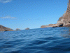
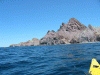 Angel de la Guarda rocky shore
Links to related images: Nearby. Proofs. Map.
Approximate location: 29.4171714782715N / 113.591590881348W.
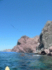
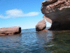
 Cave and Roca on Angel de la Guarda
Links to related images: Nearby. Proofs. Map.
Approximate location: 29.4369068145752N / 113.593307495117W.
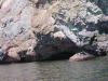
 roof of cave
Links to related images: Nearby. Proofs. Map.
Approximate location: 29.4369068145752N / 113.593307495117W.

 Patrick outside cave
Links to related images: Nearby. Proofs. Map.
Approximate location: 29.4369068145752N / 113.593307495117W.
 Pelicans over point
Links to related images: Nearby. Proofs. Map.
Approximate location: 29.4807014465332N / 113.575973510742W.
 North end of Angel de la Guarda approaching
Links to related images: Nearby. Proofs. Map.
Approximate location: 29.4969882965088N / 113.56876373291W.
 reflections in water
Links to related images: Nearby. Proofs. Map.
Approximate location: 29.5173053741455N / 113.571685791016W.
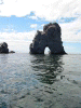
 spire of rock
Links to related images: Nearby. Proofs. Map.
Approximate location: 29.5238780975342N / 113.571853637695W.
 reflections in water
Links to related images: Nearby. Proofs. Map.
Approximate location: 29.5019187927246N / 113.566360473633W.
 small cave
Links to related images: Nearby. Proofs. Map.
Approximate location: 29.5059509277344N / 113.564300537109W.

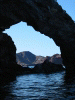
 view through arch on north of Angel de la Guarda
Links to related images: Nearby. Proofs. Map.
Approximate location: 29.5144672393799N / 113.572708129883W.
 point on north of Angel de la Guarda
Links to related images: Nearby. Proofs. Map.
Approximate location: 29.521936416626N / 113.571510314941W.
 Patrick in front of point on north of Angel de la Guarda
Links to related images: Nearby. Proofs. Map.
Approximate location: 29.5307483673096N / 113.569969177246W.
 spire of rock on north of Angel de la Guarda
Links to related images: Nearby. Proofs. Map.
Approximate location: 29.5374698638916N / 113.572372436523W.
 channel through to Bahia de Refugio
Links to related images: Nearby. Proofs. Map.
Approximate location: 29.5407562255859N / 113.572883605957W.
 roca de Angel
Links to related images: Nearby. Proofs. Map.
Approximate location: 29.5452365875244N / 113.558807373047W.
 Patrick entering Bahia de Refugio
Links to related images: Nearby. Proofs. Map.
Approximate location: 29.5452365875244N / 113.558807373047W.
 roca de Angel
Links to related images: Nearby. Proofs. Map.
Approximate location: 29.5452365875244N / 113.558807373047W.
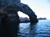
 arch in Bahia de Refugio
Links to related images: Nearby. Proofs. Map.
Approximate location: 29.5374698638916N / 113.55305480957W.
 Patrick landing in Bahia de Refugio
Links to related images: Nearby. Proofs. Map.
Approximate location: 29.5333633422852N / 113.550048828125W.
 Unloading gear in Bahia de Refugio
Links to related images: Nearby. Proofs. Map.
Approximate location: 29.5333633422852N / 113.550048828125W.
All text and images Copyright © 2003 by Mike Higgins / contact