Cabo Pulmo, May 17th to 20th 2003.
Click on the small image to see the full-sized one.
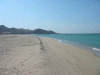

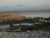
 Most of the beaches we saw on the drive down were for sale.
Links to related images: Nearby. Map.
Approximate location: 23.5N / 109.467002868652W.

 We parked our rental car behind a dive shop.
Links to related images: Nearby. Proofs. Map.
Approximate location: 23.4352149963379N / 109.426231384277W.

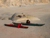
 And put the boats together the evening we arrived.
Links to related images: Nearby. Proofs. Map.
Approximate location: 23.4345836639404N / 109.426315307617W.
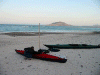
 Ready to launch the next morning.
Links to related images: Nearby. Proofs. Map.
Approximate location: 23.4344272613525N / 109.426315307617W.


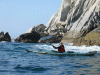
 An unsusual swell from the south.
Links to related images: Nearby. Proofs. Map.
Approximate location: 23.4236373901367N / 109.426574707031W.


 Landing on sandy beaches looking for places to camp.
Links to related images: Nearby. Proofs. Map.
Approximate location: 23.412296295166N / 109.431465148926W.

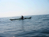
 I'm paddling the K-Light.
Links to related images: Nearby. Proofs. Map.
Approximate location: 23.4109573364258N / 109.429496765137W.

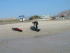
 A busy holiday beach with palapas and SUV's on the sand.
Links to related images: Nearby. Proofs. Map.
Approximate location: 23.4061527252197N / 109.426658630371W.

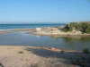
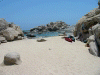
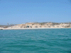
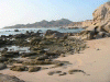
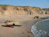
 We found a deserted beach on a point.
Links to related images: Nearby. Proofs. Map.
Approximate location: 23.4025001525879N / 109.416999816895W.

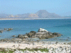
 Our beach has an incredible field of granite boulders.
Links to related images: Nearby. Proofs. Map.
Approximate location: 23.4024505615234N / 109.416275024414W.
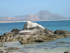
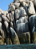
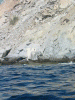
 Rock formations in the water and on land.
Links to related images: Nearby. Proofs. Map.
Approximate location: 23.4026870727539N / 109.416442871094W.
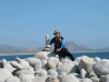
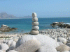
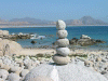
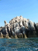
 The smooth granite cobble is stacked into 100's of stone ducks
Links to related images: Nearby. Proofs. Map.
Approximate location: 23.4023704528809N / 109.416191101074W.
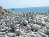
 The smooth granite cobble is stacked into 100\'s of stone ducks
Links to related images: Nearby. Proofs. Map.
Approximate location: 23.4024505615234N / 109.416107177734W.

 Rock formations in the water and on land.
Links to related images: Nearby. Proofs. Map.
Approximate location: 23.4025001525879N / 109.416999816895W.
 Using flippers that attach to my Tevas I go snorkeling and take pictures:
Links to related images: Nearby. Proofs. Map.
Approximate location: 23.4025001525879N / 109.416999816895W.


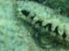 Underwater pictures taken whild snorkeling.
Links to related images: Nearby. Proofs. Map.
Approximate location: 23.4030017852783N / 109.416618347168W.

 Dive boats arrive at our 'deserted' beach.
Links to related images: Nearby. Proofs. Map.
Approximate location: 23.4031581878662N / 109.416534423828W.


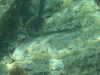

 Underwater pictures taken whild snorkeling.
Links to related images: Nearby. Proofs. Map.
Approximate location: 23.4031581878662N / 109.416534423828W.
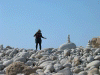
 Snorkeling must be hard work!
Links to related images: Nearby. Proofs. Map.
Approximate location: 23.4025287628174N / 109.417221069336W.
 Our campground for the night.
Links to related images: Nearby. Proofs. Map.
Approximate location: 23.4026069641113N / 109.417045593262W.

 The snails huddle together through the low tide.
Links to related images: Nearby. Proofs. Map.
Approximate location: 23.4027652740479N / 109.415672302246W.

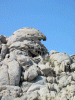
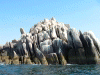
 Rock formations around our point.
Links to related images: Nearby. Proofs. Map.
Approximate location: 23.4028434753418N / 109.415077209473W.
 Dive boats arrive at our 'deserted' beach.
Links to related images: Nearby. Proofs. Map.
Approximate location: 23.4029216766357N / 109.41584777832W.

 Our beach gets larger when low tide arrives with the evening.
Links to related images: Nearby. Proofs. Map.
Approximate location: 23.4027652740479N / 109.416618347168W.

 Looking at our point from the water the next morning.
Links to related images: Nearby. Proofs. Map.
Approximate location: 23.4021339416504N / 109.415161132812W.
 Exploring the next section of coastline.
Links to related images: Nearby. Proofs. Map.
Approximate location: 23.3970928192139N / 109.414817810059W.
 Looking at our point from the water the next morning.
Links to related images: Nearby. Proofs. Map.
Approximate location: 23.4015045166016N / 109.414558410645W.


 Exploring the next section of coastline.
Links to related images: Nearby. Proofs. Map.
Approximate location: 23.3886642456055N / 109.412757873535W.

 Kate in front of a rugged shoreline
Links to related images: Nearby. Proofs. Map.
Approximate location: 23.3850402832031N / 109.412925720215W.

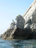
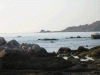
 Rugged shoreline of Cabo Frailes
Links to related images: Nearby. Proofs. Map.
Approximate location: 23.3814945220947N / 109.415328979492W.
 We have to start heading back.
Links to related images: Nearby. Proofs. Map.
Approximate location: 23.3897666931152N / 109.412582397461W.

 Exploring an offshore rock.
Links to related images: Nearby. Proofs. Map.
Approximate location: 23.4044189453125N / 109.414390563965W.
 The weekend is over, the busy beach is almost deserted.
Links to related images: Nearby. Proofs. Map.
Approximate location: 23.4063873291016N / 109.426231384277W.


 Landing for our last night of camping, half way back to Cabo Pulmo.
Links to related images: Nearby. Proofs. Map.
Approximate location: 23.4125328063965N / 109.431297302246W.
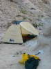

 Our tent in the mouth of a sandy arroyo, safe from the high tide.
Links to related images: Nearby. Proofs. Map.
Approximate location: 23.4121379852295N / 109.431640625W.
 Our campground by early morning light as we pack up to leave.
Links to related images: Nearby. Proofs. Map.
Approximate location: 23.4124526977539N / 109.431297302246W.
 The coast north of Cabo Pulmo, to be explored some other trip.
Links to related images: Nearby. Proofs. Map.
Approximate location: 23.434741973877N / 109.422973632812W.
 Landing at Cabo Pulmo.
Links to related images: Nearby. Proofs. Map.
Approximate location: 23.4358444213867N / 109.426315307617W.
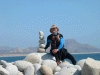
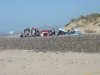 A group of Mexican college kids here to study ecology.
Links to related images: Nearby. Proofs. Map.
Approximate location: 23.4357662200928N / 109.426315307617W.

 Back home the same evening!
Links to related images: Nearby.
Approximate location: 38.3253288269043N / 122.70539855957W.
All text and images Copyright © 2003 by Mike Higgins / contact