Black Canyon, February 14th to 17th 2004.
Click on the small image to see the full-sized one.
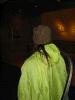
 Kate DesLauriers modeling a kayak coaming at the airport.
Links to related images: Nearby.
Approximate location: 36.0835113525391N / 115.147705078125W.
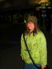
 Launching the kayaks at Willow Beach, Black Canyon.
Links to related images: Nearby. Proofs. Map.
Approximate location: 35.8671989440918N / 114.66300201416W.
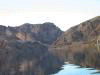
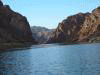
 The first few corners of the river above Willow Beach.
Links to related images: Nearby. Proofs. Map.
Approximate location: 35.8782005310059N / 114.671997070312W.
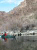
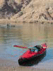
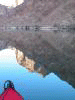
 Kate in the Feathercraft on the Colorado River.
Links to related images: Nearby. Proofs. Map.
Approximate location: 35.888355255127N / 114.68318939209W.
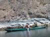
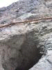 The "Catwalk" on the Colorado River, Black Canyon.
Links to related images: Nearby. Proofs. Map.
Approximate location: 35.8955879211426N / 114.693145751953W.
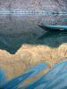 Evening light reflections on the Colorado River, Black Canyon.
Links to related images: Nearby. Proofs. Map.
Approximate location: 35.9035110473633N / 114.700698852539W.
 Our camp on Crane Canyon in the Black Canyon.
Links to related images: Nearby. Proofs. Map.
Approximate location: 35.9104995727539N / 114.706001281738W.
All text and images Copyright © 2004 by Mike Higgins / contact