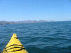
Crossing to Isla Tiburon, April 9th 2004.
Click on the small image to see the full-sized one.
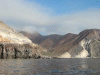
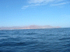
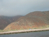 Clouds above the island
Links to related images: Nearby. Proofs. Map.
Approximate location: 28.7194957733154N / 112.524719238281W.
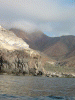
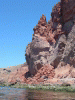
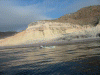 Roger lamb in front of yellow cliffs on Isla San Esteban
Links to related images: Nearby. Proofs. Map.
Approximate location: 28.7194957733154N / 112.524719238281W.
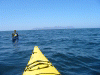
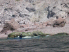
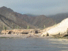 Leaving Don Joe Fred and John behind on Isla San Esteban
Links to related images: Nearby. Proofs. Map.
Approximate location: 28.7194957733154N / 112.524719238281W.
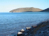
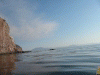 Tiburon viewed around a point on the island
Links to related images: Nearby. Proofs. Map.
Approximate location: 28.7194957733154N / 112.524719238281W.
 Clouds above the island
Links to related images: Nearby. Proofs. Map.
Approximate location: 28.7194957733154N / 112.524719238281W.
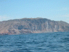
 Last close-up view of Esteban
Links to related images: Nearby. Proofs. Map.
Approximate location: 28.7194957733154N / 112.524719238281W.
 Roger Lamb in front of Isla Tiburon and Turners behind
Links to related images: Nearby. Proofs. Map.
Approximate location: 28.7514057159424N / 112.393913269043W.
 Roger Lamb in front of Isla Turners
Links to related images: Nearby. Proofs. Map.
Approximate location: 28.7514057159424N / 112.393913269043W.
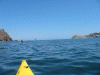
 Approaching Isla Tiburon
Links to related images: Nearby. Proofs. Map.
Approximate location: 28.7514057159424N / 112.393913269043W.
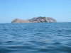
 Isla Turners in distance
Links to related images: Nearby. Proofs. Map.
Approximate location: 28.7513999938965N / 112.393997192383W.
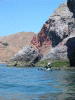
 Vertical cliffs as we approach Isla Tiburon
Links to related images: Nearby. Proofs. Map.
Approximate location: 28.7711200714111N / 112.378807067871W.
 Approaching Isla Tiburon
Links to related images: Nearby. Proofs. Map.
Approximate location: 28.7711200714111N / 112.378807067871W.
 Punta Monumento- the southern tip of Isla Tiburon
Links to related images: Nearby. Proofs. Map.
Approximate location: 28.7711200714111N / 112.378807067871W.
 Vertical cliffs as we approach island
Links to related images: Nearby. Proofs. Map.
Approximate location: 28.7736778259277N / 112.377777099609W.
 Vertical cliffs with small beach to rest on
Links to related images: Nearby. Proofs. Map.
Approximate location: 28.7736778259277N / 112.377777099609W.
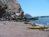
 Dave making first landing on Tiburon
Links to related images: Nearby. Proofs. Map.
Approximate location: 28.7748069763184N / 112.379920959473W.
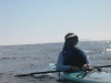
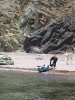
 Dave watering the ocean on Tiburon
Links to related images: Nearby. Proofs. Map.
Approximate location: 28.7748069763184N / 112.379920959473W.
 My kayak on Isla Tiburon
Links to related images: Nearby. Proofs. Map.
Approximate location: 28.7748069763184N / 112.379920959473W.
 Dave launching from rest beach
Links to related images: Nearby. Proofs. Map.
Approximate location: 28.7658538818359N / 112.362327575684W.
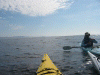
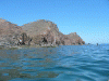
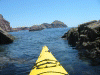 Rock gardening.
Links to related images: Nearby. Proofs. Map.
Approximate location: 28.7596836090088N / 112.357780456543W.
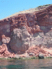
 Red rock spire
Links to related images: Nearby. Proofs. Map.
Approximate location: 28.7620162963867N / 112.360870361328W.
 Dave in front of red rock spire
Links to related images: Nearby. Proofs. Map.
Approximate location: 28.7620162963867N / 112.360870361328W.

 Small cave
Links to related images: Nearby. Proofs. Map.
Approximate location: 28.7602863311768N / 112.354942321777W.
 Green water- red cliffs
Links to related images: Nearby. Proofs. Map.
Approximate location: 28.7602863311768N / 112.354942321777W.
 Rocky point
Links to related images: Nearby. Proofs. Map.
Approximate location: 28.7596836090088N / 112.357780456543W.
 Welcome cross on rock
Links to related images: Nearby. Proofs. Map.
Approximate location: 28.763521194458N / 112.351257324219W.
 Turn colony on offshore rock
Links to related images: Nearby. Proofs. Map.
Approximate location: 28.765100479126N / 112.347480773926W.
 Dave in front of cave
Links to related images: Nearby. Proofs. Map.
Approximate location: 28.7643489837646N / 112.336235046387W.
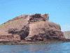
 Punta Monumento
Links to related images: Nearby. Proofs. Map.
Approximate location: 28.7542667388916N / 112.322418212891W.
 Punta Monumento- and Isla Turners
Links to related images: Nearby. Proofs. Map.
Approximate location: 28.7542667388916N / 112.322418212891W.

 Roca la Foca and Isla Turners
Links to related images: Nearby. Proofs. Map.
Approximate location: 28.7513313293457N / 112.319755554199W.
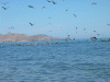
 Gulls in front of Roca la Foca and Isla Turners
Links to related images: Nearby. Proofs. Map.
Approximate location: 28.7462902069092N / 112.309967041016W.
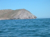
 Punta Monumento
Links to related images: Nearby. Proofs. Map.
Approximate location: 28.7462902069092N / 112.309967041016W.
 Gulls in front of Punta Monumento
Links to related images: Nearby. Proofs. Map.
Approximate location: 28.7462902069092N / 112.309967041016W.
 Shark shaped point
Links to related images: Nearby. Proofs. Map.
Approximate location: 28.763822555542N / 112.269454956055W.
 View north along the east shore of Tiburon
Links to related images: Nearby. Proofs. Map.
Approximate location: 28.7720985412598N / 112.252723693848W.
 Setting up camp on Tiburon Island
Links to related images: Nearby. Proofs. Map.
Approximate location: 28.7769889831543N / 112.262252807617W.
 View back to Punta Ast A Keem
Links to related images: Nearby. Proofs. Map.
Approximate location: 28.7769889831543N / 112.262252807617W.
All text and images Copyright © 2004 by Mike Higgins / contact