Punta Ast Ah Keem to Punta Risco Colorado, October 21st 2004,
Click on the small image to see the full-sized one.

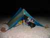 Lucy O'Brien's tent near Punta Ast Ah Keem on Isla Tiburon - Sonora
Links to related images: Nearby. Proofs. Map.
Approximate location: 28.7903022766113N / 112.271171569824W.
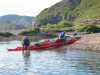
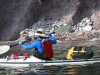
 Loading the kayaks near Punta Ast Ah Keem on Isla Tiburon - Sonora
Links to related images: Nearby. Proofs. Map.
Approximate location: 28.7903022766113N / 112.271171569824W.

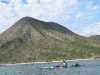
 Launching near Punta Ast Ah Keem on Isla Tiburon - Sonora
Links to related images: Nearby. Proofs. Map.
Approximate location: 28.7906036376953N / 112.267654418945W.


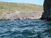
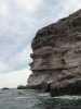
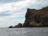
 Rocky cliff near Punta Ast Ah Keem on Isla Tiburon - Sonora
Links to related images: Nearby. Proofs. Map.
Approximate location: 28.7801475524902N / 112.267051696777W.
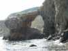
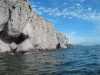
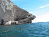
 Arch near Punta Ast Ah Keem on Isla Tiburon - Sonora
Links to related images: Nearby. Proofs. Map.
Approximate location: 28.7783432006836N / 112.263450622559W.
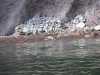
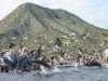 Pelicans near Punta Ast Ah Keem on Isla Tiburon - Sonora
Links to related images: Nearby. Proofs. Map.
Approximate location: 28.7784175872803N / 112.262847900391W.
 John Somers near Punta Ast Ah Keem on Isla Tiburon - Sonora
Links to related images: Nearby. Proofs. Map.
Approximate location: 28.7784175872803N / 112.262847900391W.
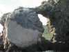
 Arch near Punta Ast Ah Keem on Isla Tiburon - Sonora
Links to related images: Nearby. Proofs. Map.
Approximate location: 28.7784175872803N / 112.262847900391W.
 John Somers near Punta Ast Ah Keem on Isla Tiburon - Sonora
Links to related images: Nearby. Proofs. Map.
Approximate location: 28.7749576568604N / 112.25821685791W.
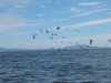
 Pelicans at Punta Ast Ah Keem on Isla Tiburon - Sonora
Links to related images: Nearby. Proofs. Map.
Approximate location: 28.7739028930664N / 112.255210876465W.
 Self arranged rocks at Punta Ast Ah Keem on Isla Tiburon - Sonora
Links to related images: Nearby. Proofs. Map.
Approximate location: 28.7707443237305N / 112.254013061523W.
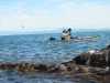
 Lucy O'Brien approaching Punta Ast Ah Keem on Isla Tiburon - Sonora
Links to related images: Nearby. Proofs. Map.
Approximate location: 28.7695407867432N / 112.253921508789W.
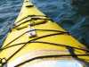 A turtle belly plate on my deck on Isla Tiburon - Sonora
Links to related images: Nearby. Proofs. Map.
Approximate location: 28.7695407867432N / 112.253921508789W.
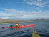
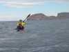
 Kayaks approaching Punta Ast Ah Keem on Isla Tiburon - Sonora
Links to related images: Nearby. Proofs. Map.
Approximate location: 28.7683353424072N / 112.253150939941W.
 Below Punta Ast Ah Keem on Isla Tiburon - Sonora
Links to related images: Nearby. Proofs. Map.
Approximate location: 28.7670574188232N / 112.253410339355W.
 Isla Turners
Links to related images: Nearby. Proofs. Map.
Approximate location: 28.7670574188232N / 112.253410339355W.
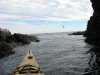
 Kayaks going through Punta Ast Ah Keem - Isla Tiburon - Sonora
Links to related images: Nearby. Proofs. Map.
Approximate location: 28.7671318054199N / 112.253150939941W.
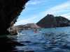
 Large Cave below Punta Ast Ah Keem - Isla Tiburon - Sonora
Links to related images: Nearby. Proofs. Map.
Approximate location: 28.7668323516846N / 112.254867553711W.
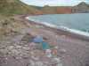
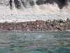 Red cobble beach below Punta Ast Ah Keem - Isla Tiburon - Sonora
Links to related images: Nearby. Proofs. Map.
Approximate location: 28.7675838470459N / 112.263191223145W.
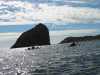
 Shark shaped point near Punta Monumento - Isla Tiburon - Sonora
Links to related images: Nearby. Proofs. Map.
Approximate location: 28.7648754119873N / 112.266540527344W.
 Landing for a break near Punta Monumento - Isla Tiburon - Sonora
Links to related images: Nearby. Proofs. Map.
Approximate location: 28.761791229248N / 112.293922424316W.
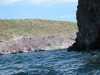
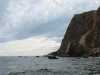
 Rocky cliffs near Punta Monumento - Isla Tiburon - Sonora
Links to related images: Nearby. Proofs. Map.
Approximate location: 28.7473430633545N / 112.308769226074W.
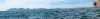
 Isla Turner and Roca la Foca from Punta Monumento - Isla Tiburon - Sonora
Links to related images: Nearby. Proofs. Map.
Approximate location: 28.7466659545898N / 112.309539794922W.
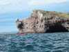
 Rocky cliffs near Punta Monumento
Links to related images: Nearby. Proofs. Map.
Approximate location: 28.7467403411865N / 112.310913085938W.
 Don Fleming heading towards Punta Colorado - Isla Tiburon - Sonora
Links to related images: Nearby. Proofs. Map.
Approximate location: 28.75N / 112.316665649414W.
 Caves at Punta Colorado - Isla Tiburon - Sonora
Links to related images: Nearby. Proofs. Map.
Approximate location: 28.7613391876221N / 112.351943969727W.
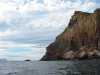 Cliffs at Punta Colorado - Isla Tiburon - Sonora
Links to related images: Nearby. Proofs. Map.
Approximate location: 28.7596092224121N / 112.356918334961W.
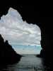
 Looking out big cave at Punta Colorado - Isla Tiburon - Sonora
Links to related images: Nearby. Proofs. Map.
Approximate location: 28.7596092224121N / 112.356918334961W.


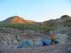 Camping at Punta Colorado - Isla Tiburon - Sonora
Links to related images: Nearby. Proofs. Map.
Approximate location: 28.7751064300537N / 112.367988586426W.
 Cave above camp at Punta Colorado - Isla Tiburon - Sonora
Links to related images: Nearby. Proofs. Map.
Approximate location: 28.7751064300537N / 112.367988586426W.
All text and images Copyright © 2004 by Mike Higgins / contact