West Isla Tiburon to Bahia Agua Dulce, October 27th 2004.
Click on the small image to see the full-sized one.
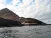 Looking back at the campsite on the west side of Isla Tiburon
Links to related images: Nearby. Proofs. Map.
Approximate location: 29.0569190979004N / 112.502746582031W.
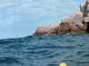
 Each point on the west side of Isla Tiburon had rough water
Links to related images: Nearby. Proofs. Map.
Approximate location: 29.0633716583252N / 112.505668640137W.
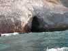
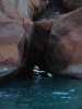 Lucy O'Brien in small cave on the west side of Isla Tiburon
Links to related images: Nearby. Proofs. Map.
Approximate location: 29.071849822998N / 112.494331359863W.
 I had to land to change memory cards in my camera
Links to related images: Nearby. Proofs. Map.
Approximate location: 29.0855770111084N / 112.492446899414W.
 The northern most point of the west side of Isla Tiburon?
Links to related images: Nearby. Proofs. Map.
Approximate location: 29.0996761322021N / 112.491760253906W.

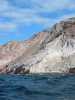
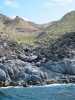 Steep rocky shoreline of the west side of Isla Tiburon
Links to related images: Nearby. Proofs. Map.
Approximate location: 29.1329708099365N / 112.485580444336W.
 Steep rocky shoreline of the west side of Isla Tiburon
Links to related images: Nearby. Proofs. Map.
Approximate location: 29.1488628387451N / 112.477684020996W.
 The northern most point of the west side of Isla Tiburon?
Links to related images: Nearby. Proofs. Map.
Approximate location: 29.1629543304443N / 112.476997375488W.
 Steep rocky shoreline of the west side of Isla Tiburon
Links to related images: Nearby. Proofs. Map.
Approximate location: 29.1758460998535N / 112.469444274902W.
 Lucy O'Brien and John Somers in bumpy water on the west side of Isla Tiburon
Links to related images: Nearby. Proofs. Map.
Approximate location: 29.1671524047852N / 112.479057312012W.
 Steep rocky shoreline of the west side of Isla Tiburon
Links to related images: Nearby. Proofs. Map.
Approximate location: 29.1695499420166N / 112.475280761719W.
 The northern most point of the west side of Isla Tiburon?
Links to related images: Nearby. Proofs. Map.
Approximate location: 29.1779441833496N / 112.468414306641W.
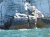
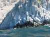 Vertical cliffs on the west side of Isla Tiburon
Links to related images: Nearby. Proofs. Map.
Approximate location: 29.1683502197266N / 112.478370666504W.
 The northern most point of the west side of Isla Tiburon?
Links to related images: Nearby. Proofs. Map.
Approximate location: 29.1776447296143N / 112.47013092041W.
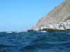
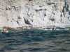
 Kayaks in bumpy water on the west side of Isla Tiburon
Links to related images: Nearby. Proofs. Map.
Approximate location: 29.1674518585205N / 112.478713989258W.
 Landed on a ganite cobble beach for lunch on Isla Tiburon
Links to related images: Nearby. Proofs. Map.
Approximate location: 29.1768951416016N / 112.467041015625W.

 Evidence that others have landed on this beach on Isla Tiburon
Links to related images: Nearby. Proofs. Map.
Approximate location: 29.1768951416016N / 112.467041015625W.
 Landed on a ganite cobble beach for lunch on Isla Tiburon
Links to related images: Nearby. Proofs. Map.
Approximate location: 29.1768951416016N / 112.467041015625W.
 Water ripple on granite cobble on Isla Tiburon
Links to related images: Nearby. Proofs. Map.
Approximate location: 29.1768951416016N / 112.467041015625W.


 Kayaks in bumpy water on the west side of Isla Tiburon
Links to related images: Nearby. Proofs. Map.
Approximate location: 29.1918811798096N / 112.458976745605W.

 Fin whale skelliton on the west side of Isla Tiburon
Links to related images: Nearby. Proofs. Map.
Approximate location: 29.1951789855957N / 112.454681396484W.
 Water carved granite point on the west side of Isla Tiburon
Links to related images: Nearby. Proofs. Map.
Approximate location: 29.1996746063232N / 112.449531555176W.
 Possible camping beach on the west side of Isla Tiburon
Links to related images: Nearby. Proofs. Map.
Approximate location: 29.1978759765625N / 112.450218200684W.
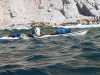
 Really bumpy water on the west side of Isla Tiburon
Links to related images: Nearby. Proofs. Map.
Approximate location: 29.1977252960205N / 112.453308105469W.


 The northern most point of the west side of Isla Tiburon?
Links to related images: Nearby. Proofs. Map.
Approximate location: 29.1998233795166N / 112.449188232422W.


 The water calms down on the north side of Isla Tiburon
Links to related images: Nearby. Proofs. Map.
Approximate location: 29.1993751525879N / 112.438888549805W.
 Basalt plug on the north side of Isla Tiburon
Links to related images: Nearby. Proofs. Map.
Approximate location: 29.2004222869873N / 112.436653137207W.
 Gentile point on the north side of Isla Tiburon
Links to related images: Nearby. Proofs. Map.
Approximate location: 29.2004222869873N / 112.434425354004W.

 Clouds of boobies on the north side of Isla Tiburon
Links to related images: Nearby. Proofs. Map.
Approximate location: 29.2004222869873N / 112.432876586914W.
 Bahia Agua Dulce on Isla Tiburon
Links to related images: Nearby. Proofs. Map.
Approximate location: 29.1996746063232N / 112.431854248047W.
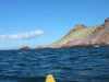
 Hills on the west end of Bahia Agua Dulce
Links to related images: Nearby. Proofs. Map.
Approximate location: 29.1977252960205N / 112.431335449219W.
 Cactus driftwood on the berm at the west end of Bahia Agua Dulce
Links to related images: Nearby. Proofs. Map.
Approximate location: 29.1950283050537N / 112.431335449219W.
 Old pier in Bahia Agua Dulce on Tiburon Island
Links to related images: Nearby. Proofs. Map.
Approximate location: 29.1876850128174N / 112.417434692383W.
All text and images Copyright © 2004 by Mike Higgins / contact