Blaquier Point to Ideal Cove, June 20th 2005.
Click on the small image to see the full-sized one.
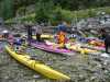
 Loading the kayaks at Blaquiere Point
Links to related images: Nearby. Proofs. Map.
Approximate location: 56.5842514038086N / 132.54313659668W.
 Scott, our outfitter, at Blaquiere Point
Links to related images: Nearby. Proofs. Map.
Approximate location: 56.5842514038086N / 132.54313659668W.
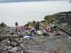
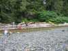
 Finally on the water at Blaquiere Point
Links to related images: Nearby. Proofs. Map.
Approximate location: 56.5842514038086N / 132.54313659668W.
 Our first eagle near Blaquiere Point
Links to related images: Nearby. Proofs. Map.
Approximate location: 56.5842514038086N / 132.54313659668W.
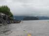
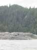
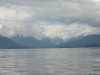
 Low overcast and smoking islands in Dry Sound
Links to related images: Nearby. Proofs. Map.
Approximate location: 56.6116790771484N / 132.553192138672W.
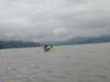
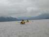
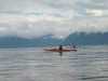 Ruth Cooper and Don Flemming in Dry Sound
Links to related images: Nearby. Proofs. Map.
Approximate location: 56.6116790771484N / 132.553192138672W.
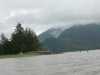
 Glimpses of snowy mountains from Dry Sound
Links to related images: Nearby. Proofs. Map.
Approximate location: 56.6116790771484N / 132.553192138672W.
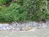
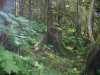 The forest primevil at Ideal Cove
Links to related images: Nearby. Proofs. Map.
Approximate location: 56.6786994934082N / 132.657333374023W.
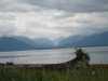 The view from Ideal Cove across to LeConte Bay
Links to related images: Nearby. Proofs. Map.
Approximate location: 56.6786994934082N / 132.657333374023W.
 Kayaks parked above the high tide at Ideal Cove
Links to related images: Nearby. Proofs. Map.
Approximate location: 56.6786994934082N / 132.657333374023W.
All text and images Copyright © 2005 by Mike Higgins / contact