Ideal Cove to Bussy Creek, June 21st 2005.
Click on the small image to see the full-sized one.

 Launching at low tide from Ideal Cove
Links to related images: Nearby. Proofs. Map.
Approximate location: 56.6786994934082N / 132.657333374023W.
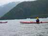
 Paddling accross Frederick Sound from Ideal Cove
Links to related images: Nearby. Proofs. Map.
Approximate location: 56.6786994934082N / 132.657333374023W.
 Ruth Cooper launching from Ideal Cove
Links to related images: Nearby. Proofs. Map.
Approximate location: 56.6786994934082N / 132.657333374023W.
 Jesse Meyer and John Somers launching from Ideal Cove
Links to related images: Nearby. Proofs. Map.
Approximate location: 56.6786994934082N / 132.656997680664W.
 Passing Coney Island in Frederick Sound
Links to related images: Nearby. Proofs. Map.
Approximate location: 56.6927680969238N / 132.640884399414W.
 McDonald Island in the distance on Frederick Sound
Links to related images: Nearby. Proofs. Map.
Approximate location: 56.7193412780762N / 132.580810546875W.
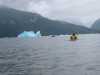
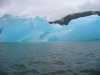
 Don Fleming in front of our first iceburgs at LeConte Bay
Links to related images: Nearby. Proofs. Map.
Approximate location: 56.7415313720703N / 132.54362487793W.
 Kate DesLauriers in front of iceburgs at LeConte Bay
Links to related images: Nearby. Proofs. Map.
Approximate location: 56.7415313720703N / 132.54362487793W.
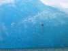
 Birds on iceburgs at LeConte Bay
Links to related images: Nearby. Proofs. Map.
Approximate location: 56.7415313720703N / 132.54362487793W.
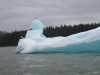
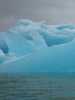
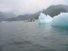
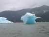 Cyan blue iceburgs at LeConte Bay
Links to related images: Nearby. Proofs. Map.
Approximate location: 56.7415313720703N / 132.54362487793W.
 Birds on iceburgs at LeConte Bay
Links to related images: Nearby. Proofs. Map.
Approximate location: 56.7415313720703N / 132.54362487793W.
 Kate DesLauriers in front of iceburgs at LeConte Bay
Links to related images: Nearby. Proofs. Map.
Approximate location: 56.7415313720703N / 132.54362487793W.
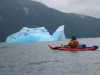
 Don Fleming in front of iceburgs at LeConte Bay
Links to related images: Nearby. Proofs. Map.
Approximate location: 56.7415313720703N / 132.54362487793W.
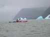
 Joe Petolino in front of iceburgs at LeConte Bay
Links to related images: Nearby. Proofs. Map.
Approximate location: 56.7415313720703N / 132.54362487793W.
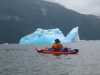
 Don Fleming in front of iceburgs at LeConte Bay
Links to related images: Nearby. Proofs. Map.
Approximate location: 56.7415313720703N / 132.54362487793W.
 Joe Petolino in front of iceburgs at LeConte Bay
Links to related images: Nearby. Proofs. Map.
Approximate location: 56.7415313720703N / 132.54362487793W.
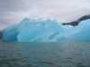
 Don Fleming in front of iceburgs at LeConte Bay
Links to related images: Nearby. Proofs. Map.
Approximate location: 56.7415313720703N / 132.54362487793W.
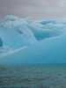
 Cyan blue iceburgs in LeConte Bay
Links to related images: Nearby. Proofs. Map.
Approximate location: 56.7709808349609N / 132.512115478516W.
 Bear shaped ice sculpture on iceburg in LeConte Bay
Links to related images: Nearby. Proofs. Map.
Approximate location: 56.7709808349609N / 132.512115478516W.

 Rock in cyan blue iceburg in LeConte Bay
Links to related images: Nearby. Proofs. Map.
Approximate location: 56.7709808349609N / 132.512115478516W.
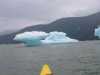
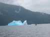
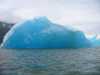
 Yet another iceburg in LeConte Bay
Links to related images: Nearby. Proofs. Map.
Approximate location: 56.7709808349609N / 132.512115478516W.
 John Somers behind iceburg in LeConte Bay
Links to related images: Nearby. Proofs. Map.
Approximate location: 56.7709808349609N / 132.512115478516W.

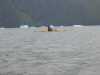
 Joe Petolino and Jesse Meyer in LeConte Bay
Links to related images: Nearby. Proofs. Map.
Approximate location: 56.7851982116699N / 132.503997802734W.

 Grounded burgy bit in LeConte Bay
Links to related images: Nearby. Proofs. Map.
Approximate location: 56.7851982116699N / 132.504058837891W.
 Forest campground at Bussy Creek
Links to related images: Nearby. Proofs. Map.
Approximate location: 56.7899398803711N / 132.505157470703W.
 The meadow at Bussy Creek
Links to related images: Nearby. Proofs. Map.
Approximate location: 56.7899398803711N / 132.505157470703W.

 The sun comes out at Bussy Creek
Links to related images: Nearby. Proofs. Map.
Approximate location: 56.7901382446289N / 132.509918212891W.
All text and images Copyright © 2005 by Mike Higgins / contact