The LeConte Glacier, June 22nd 2005.
Click on the small image to see the full-sized one.
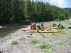
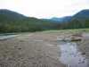
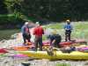 Packing the kayaks in the morning at Bussy Creek
Links to related images: Nearby. Proofs. Map.
Approximate location: 56.7901382446289N / 132.509918212891W.
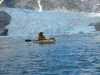
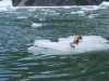
 First iceburg in the morning in LeConte Bay
Links to related images: Nearby. Proofs. Map.
Approximate location: 56.785701751709N / 132.500396728516W.
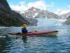
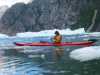
 Lisa Rohe behind iceburg in LeConte Bay
Links to related images: Nearby. Proofs. Map.
Approximate location: 56.785701751709N / 132.500396728516W.
 Mountains, sky, clouds, iceburg, reflections.
Links to related images: Nearby. Proofs. Map.
Approximate location: 56.785701751709N / 132.500396728516W.
 Source of the thunder at Thunder Point
Links to related images: Nearby. Proofs. Map.
Approximate location: 56.7842903137207N / 132.454406738281W.

 Snowy mountains from LeConte Bay
Links to related images: Nearby. Proofs. Map.
Approximate location: 56.7842903137207N / 132.454406738281W.
 Crouded iceburgs in LeConte Bay
Links to related images: Nearby. Proofs. Map.
Approximate location: 56.8045616149902N / 132.451095581055W.

 Burgy bits fill LeConte Bay
Links to related images: Nearby. Proofs. Map.
Approximate location: 56.8045616149902N / 132.451095581055W.
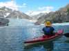
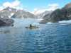
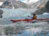
 Kayakers go behing iceburgs in LeConte Bay
Links to related images: Nearby. Proofs. Map.
Approximate location: 56.8045616149902N / 132.451095581055W.
 Cyan blue iceburg in LeConte Bay
Links to related images: Nearby. Proofs. Map.
Approximate location: 56.8045616149902N / 132.451095581055W.


 Balancing burg iceburg in LeConte Bay
Links to related images: Nearby. Proofs. Map.
Approximate location: 56.8149490356445N / 132.433151245117W.
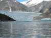
 First views of LeConte Glacier
Links to related images: Nearby. Proofs. Map.
Approximate location: 56.8149490356445N / 132.433151245117W.


 Floatplane gives a tour of the LeConte Glacier
Links to related images: Nearby. Proofs. Map.
Approximate location: 56.8149490356445N / 132.433151245117W.

 Jesse Meyer in front of iceburgs in LeConte Bay
Links to related images: Nearby. Proofs. Map.
Approximate location: 56.8149490356445N / 132.433151245117W.


 Mountains reflected around burgy bits in LeConte Bay
Links to related images: Nearby. Proofs. Map.
Approximate location: 56.8149490356445N / 132.433151245117W.

 Lisa Rohe in front of burgy bits in LeConte Bay
Links to related images: Nearby. Proofs. Map.
Approximate location: 56.8149490356445N / 132.433151245117W.
 Rocky mountains above LeConte Bay
Links to related images: Nearby. Proofs. Map.
Approximate location: 56.8149490356445N / 132.433151245117W.
 Don Fleming in LeConte Bay
Links to related images: Nearby. Proofs. Map.
Approximate location: 56.8149490356445N / 132.433151245117W.
 Lisa Rohe in LeConte Bay
Links to related images: Nearby. Proofs. Map.
Approximate location: 56.8149490356445N / 132.433151245117W.
 Mountains reflected around burgy bits in LeConte Bay
Links to related images: Nearby. Proofs. Map.
Approximate location: 56.8149490356445N / 132.433151245117W.
 As close as we dared to the LeConte Glacier
Links to related images: Nearby. Proofs. Map.
Approximate location: 56.8229217529297N / 132.383865356445W.
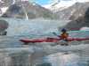
 Joe Petolino in front of the LeConte Glacier
Links to related images: Nearby. Proofs. Map.
Approximate location: 56.8229217529297N / 132.383865356445W.
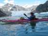
 John Somers in front of the LeConte Glacier
Links to related images: Nearby. Proofs. Map.
Approximate location: 56.8229217529297N / 132.383865356445W.
 Lupytha's photo shoot at the LeConte Glacier
Links to related images: Nearby. Proofs. Map.
Approximate location: 56.8229217529297N / 132.383865356445W.

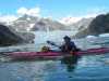
 Don Fleming in front of the LeConte Glacier
Links to related images: Nearby. Proofs. Map.
Approximate location: 56.8229217529297N / 132.383865356445W.
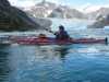 Jesse Meyer in front of the LeConte Glacier
Links to related images: Nearby. Proofs. Map.
Approximate location: 56.8228988647461N / 132.384002685547W.
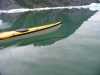
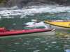
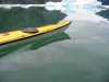 Kayak reflecting with burgy bits in LeConte Bay
Links to related images: Nearby. Proofs. Map.
Approximate location: 56.8229217529297N / 132.383865356445W.


 Yet another cyan blue iceburg in LeConte Bay
Links to related images: Nearby. Proofs. Map.
Approximate location: 56.7931594848633N / 132.449996948242W.


 Grounded burgy bits on the way back to Bussy Creek
Links to related images: Nearby. Proofs. Map.
Approximate location: 56.7867088317871N / 132.475845336914W.
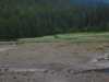
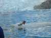
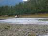 Mother moose and calf at Bussy Creek
Links to related images: Nearby. Proofs. Map.
Approximate location: 56.7785415649414N / 132.510284423828W.
All text and images Copyright © 2005 by Mike Higgins / contact