Bussy Creek to Icy Cove, June 23rd 2005.
Click on the small image to see the full-sized one.
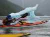
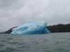
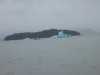
 Iceburg with arch near Bussy Creek
Links to related images: Nearby. Proofs. Map.
Approximate location: 56.7785415649414N / 132.510284423828W.
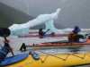
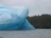
 John Somers going throug iceburg arch near Bussy Creek
Links to related images: Nearby. Proofs. Map.
Approximate location: 56.7785415649414N / 132.510284423828W.
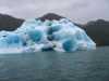
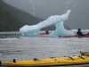
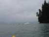
 Yet another cyan blue iceburg in LeConte Bay
Links to related images: Nearby. Proofs. Map.
Approximate location: 56.7624015808105N / 132.517074584961W.
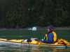
 Kayaks in front of Camp Island
Links to related images: Nearby. Proofs. Map.
Approximate location: 56.7624015808105N / 132.517074584961W.
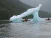
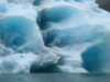
 Our last iceburg leaving LeConte Bay
Links to related images: Nearby. Proofs. Map.
Approximate location: 56.7519187927246N / 132.548950195312W.
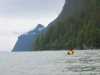
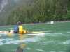 Kate DesLauriers near the shore of Fredrick Sound
Links to related images: Nearby. Proofs. Map.
Approximate location: 56.762508392334N / 132.586685180664W.
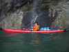 Don Fleming in front of small waterfall in Fredgrick Sound
Links to related images: Nearby. Proofs. Map.
Approximate location: 56.7651290893555N / 132.59309387207W.
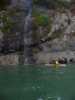 Kate DesLauriers in front of small waterfall in Fredgrick Sound
Links to related images: Nearby. Proofs. Map.
Approximate location: 56.7651290893555N / 132.59309387207W.
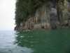 Kate DesLauriers near the shore of Fredrick Sound
Links to related images: Nearby. Proofs. Map.
Approximate location: 56.7651290893555N / 132.59309387207W.
All text and images Copyright © 2005 by Mike Higgins / contact