Wood Point to East Sukoi Island, June 27th 2005.
Click on the small image to see the full-sized one.
 Morning at Wood Point
Links to related images: Nearby. Proofs. Map.
Approximate location: 56.9929504394531N / 132.941665649414W.

 Jesse Meyer following the tide out at Wood Point
Links to related images: Nearby. Proofs. Map.
Approximate location: 56.9930000305176N / 132.942001342773W.
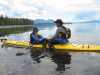
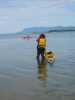 Kate DesLauriers ready to launch at Wood Point
Links to related images: Nearby. Proofs. Map.
Approximate location: 56.9929504394531N / 132.941665649414W.
 Ruth Cooper paddling away from Wood Point
Links to related images: Nearby. Proofs. Map.
Approximate location: 56.9929504394531N / 132.941665649414W.
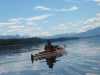
 John Somers paddling away from Wood Point
Links to related images: Nearby. Proofs. Map.
Approximate location: 56.9929504394531N / 132.941665649414W.
 John Somers stopped at watering hole creek
Links to related images: Nearby. Proofs. Map.
Approximate location: 56.9652214050293N / 132.91389465332W.
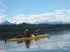
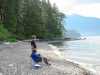
 Lisa Rohe and Jesse Meyer at watering hole creek
Links to related images: Nearby. Proofs. Map.
Approximate location: 56.9651985168457N / 132.914001464844W.
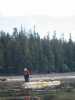
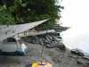
 Camping on the beach on East Sukoi Island
Links to related images: Nearby. Proofs. Map.
Approximate location: 56.8931083679199N / 132.914993286133W.
 Don Fleming and Jesse Meyer on East Sukoi Island
Links to related images: Nearby. Proofs. Map.
Approximate location: 56.8931007385254N / 132.914993286133W.
 Tent under rain tarp on East Sukoi Island
Links to related images: Nearby. Proofs. Map.
Approximate location: 56.8931083679199N / 132.914993286133W.
 The view north from the Sukoi Islands
Links to related images: Nearby. Proofs. Map.
Approximate location: 56.8931083679199N / 132.914993286133W.
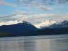 Mountains viewed from the Sukoi Islands
Links to related images: Nearby. Proofs. Map.
Approximate location: 56.8931083679199N / 132.914993286133W.
All text and images Copyright © 2005 by Mike Higgins / contact