Oceanside to San Elijo State Beach, September 28th 2005.
Click on the small image to see the full-sized one.
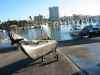 Rolling to the public boat ramp in the Oceanside Harbor
Links to related images: Nearby. Proofs. Map.
Approximate location: 33.2040710449219N / 117.391632080078W.
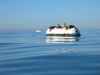
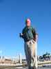 I met Ray, who works for the city parks department at the harbor
Links to related images: Nearby. Proofs. Map.
Approximate location: 33.2040710449219N / 117.391632080078W.
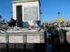
 The egrets are fearless on the docks in Oceanside Harbor!
Links to related images: Nearby. Proofs. Map.
Approximate location: 33.2040710449219N / 117.391632080078W.
 The Oceanside Pier in the morning.
Links to related images: Nearby. Proofs. Map.
Approximate location: 33.1909790039062N / 117.389953613281W.
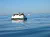
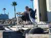
 Sea lions on offshore mooring buoys
Links to related images: Nearby. Proofs. Map.
Approximate location: 33.1768188476562N / 117.376289367676W.
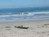 Landed at San Elijo State Beach
Links to related images: Nearby. Proofs. Map.
Approximate location: 33.0163803100586N / 117.282386779785W.
All text and images Copyright © 2005 by Mike Higgins / contact