San Elijo State Park to Mission Bay, September 29th 2005.
Click on the small image to see the full-sized one.
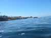
 Ready to launch at San Elijo State Beach
Links to related images: Nearby. Proofs. Map.
Approximate location: 33.0163803100586N / 117.282386779785W.

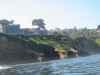
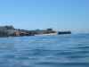
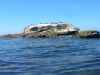
 A barge set up to build a new pier at Cardiff-by-the-Sea
Links to related images: Nearby. Proofs. Map.
Approximate location: 33.0138893127441N / 117.283546447754W.
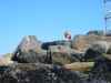
 Lookout at clifftop at Torrey Pines State Reserve
Links to related images: Nearby. Proofs. Map.
Approximate location: 32.9030990600586N / 117.257499694824W.
 I cought only one fuzzy picture of a bottlenose dolphin this whole trip
Links to related images: Nearby. Proofs. Map.
Approximate location: 32.9030990600586N / 117.257499694824W.
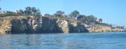
 Cliffs at Torrey Pines State Reserve
Links to related images: Nearby. Proofs. Map.
Approximate location: 32.9030990600586N / 117.257499694824W.
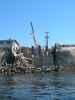
 A structure by the water with an elevator track up to a house.
Links to related images: Nearby. Proofs. Map.
Approximate location: 32.8725395202637N / 117.258140563965W.
 Kayak fisherman near Scripps Institute
Links to related images: Nearby. Proofs. Map.
Approximate location: 32.8725395202637N / 117.258140563965W.
 Scripps Institute jet ski with instrument package on side
Links to related images: Nearby. Proofs. Map.
Approximate location: 32.8725395202637N / 117.258140563965W.
 The Scripps Institute of Oceanography pier
Links to related images: Nearby. Proofs. Map.
Approximate location: 32.8663787841797N / 117.257621765137W.
 The Scripps Institute launches an ROV off the pier
Links to related images: Nearby. Proofs. Map.
Approximate location: 32.8663787841797N / 117.257621765137W.

 A man walking on waer at La Jolla
Links to related images: Nearby. Proofs. Map.
Approximate location: 32.8550109863281N / 117.26220703125W.
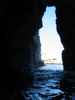
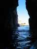
 Caves in the cliffs at La Jolla
Links to related images: Nearby. Proofs. Map.
Approximate location: 32.8503303527832N / 117.265548706055W.
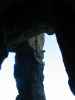
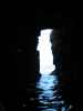
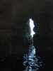
 Inside the La Jolla Caves, the only ones I got to play in on this trip
Links to related images: Nearby. Proofs. Map.
Approximate location: 32.8503303527832N / 117.265548706055W.
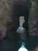
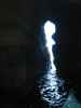
 Inside the La Jolla Caves, I went into two different ones here.
Links to related images: Nearby. Proofs. Map.
Approximate location: 32.8503303527832N / 117.265548706055W.
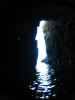
 An outfitter takes a group inside the La Jolla Caves
Links to related images: Nearby. Proofs. Map.
Approximate location: 32.8503303527832N / 117.265548706055W.
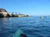
 A protected sandy beach behind Seal Rock
Links to related images: Nearby. Proofs. Map.
Approximate location: 32.8486213684082N / 117.278221130371W.
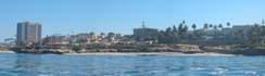 The La Jolla costline reminds me of Monterey, with high-rise buildings
Links to related images: Nearby. Proofs. Map.
Approximate location: 32.8452987670898N / 117.282447814941W.
 Impressive new beachfront foundation in La Jolla
Links to related images: Nearby. Proofs. Map.
Approximate location: 32.8139610290527N / 117.2763671875W.
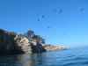
 Birds on Bird Rock at La Jolla
Links to related images: Nearby. Proofs. Map.
Approximate location: 32.8139610290527N / 117.2763671875W.
 A picture of depression at the end of the Mission Bay Jetty
Links to related images: Nearby. Proofs. Map.
Approximate location: 32.7582015991211N / 117.260459899902W.
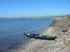 Stopped on Fiesta Island in Mission Bay for a break
Links to related images: Nearby. Proofs. Map.
Approximate location: 32.7760696411133N / 117.224227905273W.
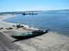 Laned for the evening at apublic boat ramp in Mission Bay
Links to related images: Nearby. Proofs. Map.
Approximate location: 32.7933006286621N / 117.209533691406W.
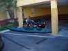 Sharing a parking space with a Harley at the motel in San Diego
Links to related images: Nearby. Proofs. Map.
Approximate location: 32.8023414611816N / 117.216239929199W.
All text and images Copyright © 2005 by Mike Higgins / contact