Punta Cerro Prieto to Palm Valley, April 8th 2006.
Click on the small image to see the full-sized one.
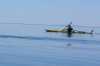
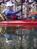
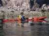
 John Weed and I paddling north to the Valley of the Palms
Links to related images: Nearby. Proofs. Map.
Approximate location: 29.09352684021N / 113.151885986328W.
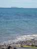
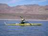 The intrepid kayaker paddling north to the Valley of the Palms
Links to related images: Nearby.
Approximate location: 29.1025276184082N / 113.155143737793W.
 The intrepid kayaker at False Palm Beach
Links to related images: Nearby. Proofs. Map.
Approximate location: 29.1901588439941N / 113.16716003418W.
 John Weed at False Palm Beach
Links to related images: Nearby. Proofs. Map.
Approximate location: 29.1901588439941N / 113.16716003418W.
 The intrepid kayaker posing in John's Palm Valley
Links to related images: Nearby. Proofs. Map.
Approximate location: 29.2072410583496N / 113.181838989258W.
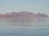
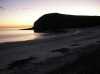 Sunrise at Punta Cerro Prieto
Links to related images: Nearby. Proofs. Map.
Approximate location: 29.0566940307617N / 113.124671936035W.
 Don Fleming and Dave Harry launching from Punta Cerro Prieto
Links to related images: Nearby. Proofs. Map.
Approximate location: 29.0586452484131N / 113.123558044434W.
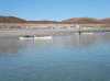
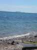
 Shallow water and white sand of Punta Cerro Prieto
Links to related images: Nearby. Proofs. Map.
Approximate location: 29.0586452484131N / 113.123558044434W.
 Don Fleming in calm water off Punta Cerro Prieto
Links to related images: Nearby. Proofs. Map.
Approximate location: 29.0597705841064N / 113.124244689941W.
 Doug Hamilton in calm water off Punta Cerro Prieto
Links to related images: Nearby. Proofs. Map.
Approximate location: 29.0597705841064N / 113.124244689941W.
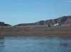
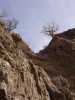
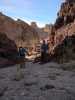
 Somewhere in these cliffs is the Valley of the Palms
Links to related images: Nearby. Proofs. Map.
Approximate location: 29.0643482208252N / 113.129653930664W.
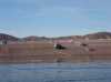
 A panga fishing camp at the old clam processing pier
Links to related images: Nearby. Proofs. Map.
Approximate location: 29.0636730194092N / 113.140983581543W.
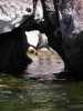
 A small arch on the shore of Isla Angel de la Guarda
Links to related images: Nearby. Proofs. Map.
Approximate location: 29.093376159668N / 113.155059814453W.
 Doug Hamilton rock gardening on the shore of Isla Angel de la Guarda
Links to related images: Nearby.
Approximate location: 29.1125755310059N / 113.165016174316W.
 John Somers and Don Fleming paddling up the east shore of Ilsa Angel de la Guarda
Links to related images: Nearby. Proofs. Map.
Approximate location: 29.1410675048828N / 113.169479370117W.
 The east shore of Ilsa Angel de la Guarda south of Punta Arena
Links to related images: Nearby. Proofs. Map.
Approximate location: 29.1521606445312N / 113.167762756348W.
 Dave Harry in calm water on the east shore of Ilsa Angel de la Guarda
Links to related images: Nearby. Proofs. Map.
Approximate location: 29.163854598999N / 113.16707611084W.
 John Somers in calm water on the east shore of Ilsa Angel de la Guarda
Links to related images: Nearby.
Approximate location: 29.1746463775635N / 113.166389465332W.
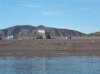
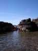
 We called this beach on Punta Arena the False Palm Beach
Links to related images: Nearby. Proofs. Map.
Approximate location: 29.1896343231201N / 113.167251586914W.
 Dave Harry and John Weed on False Palm Beach
Links to related images: Nearby. Proofs. Map.
Approximate location: 29.1896343231201N / 113.167251586914W.
 Fata Morgana optical illusion over Isla el Estanque
Links to related images: Nearby. Proofs. Map.
Approximate location: 29.1896343231201N / 113.167251586914W.
 John Weed's Palm Valley, no palms visible up the arroyo
Links to related images: Nearby. Proofs. Map.
Approximate location: 29.2065658569336N / 113.172401428223W.
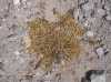 Weed seed pods in John's Palm Valley
Links to related images: Nearby. Proofs. Map.
Approximate location: 29.2065658569336N / 113.172401428223W.
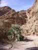
 The one palm tree near the beach in Palm Valley
Links to related images: Nearby. Proofs. Map.
Approximate location: 29.207914352417N / 113.171714782715W.
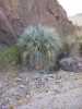
 Eliphant tree in the Palm Valley
Links to related images: Nearby. Proofs. Map.
Approximate location: 29.2068672180176N / 113.176689147949W.

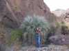
 John Somers next to the first adult palm tree in Palm Valley
Links to related images: Nearby. Proofs. Map.
Approximate location: 29.2082901000977N / 113.181579589844W.
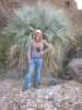
 The intrepid kayaker posing in front of a tree in Palm Valley
Links to related images: Nearby. Proofs. Map.
Approximate location: 29.2082901000977N / 113.181579589844W.
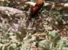 Giant wasp in Palm Valley
Links to related images: Nearby. Proofs. Map.
Approximate location: 29.208963394165N / 113.182441711426W.


 Rattlesnake in Palm Valley
Links to related images: Nearby. Proofs. Map.
Approximate location: 29.2108364105225N / 113.186561584473W.

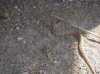 Rattlesnake in Palm Valley.
Links to related images: Nearby. Proofs. Map.
Approximate location: 29.2108364105225N / 113.186561584473W.
 A second adult palm tree in Palm Valley
Links to related images: Nearby. Proofs. Map.
Approximate location: 29.2111358642578N / 113.188102722168W.
 Doug Hamilton in front of a third adult palm tree in Palm Valley
Links to related images: Nearby. Proofs. Map.
Approximate location: 29.2108364105225N / 113.18896484375W.
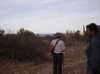
 John Somers and Don Fleming in front of tree in Palm Valley
Links to related images: Nearby. Proofs. Map.
Approximate location: 29.2108364105225N / 113.18896484375W.
 Palm seeds in Palm Valley
Links to related images: Nearby. Proofs. Map.
Approximate location: 29.2108364105225N / 113.18896484375W.
 A classic double palm tree in Palm Valley
Links to related images: Nearby. Proofs. Map.
Approximate location: 29.2097129821777N / 113.191192626953W.


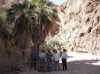 Group photo in front of the douple palms
Links to related images: Nearby. Proofs. Map.
Approximate location: 29.2096385955811N / 113.191108703613W.
 There were fewer than a dozen palms in this whole valley
Links to related images: Nearby. Proofs. Map.
Approximate location: 29.2097129821777N / 113.192306518555W.
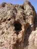 Cave in the wall of Palm Valley
Links to related images: Nearby. Proofs. Map.
Approximate location: 29.2093391418457N / 113.192909240723W.
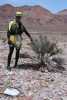
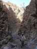
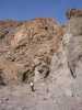 John Somers hiking in Palm Valley
Links to related images: Nearby. Proofs. Map.
Approximate location: 29.2088890075684N / 113.194282531738W.
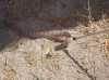
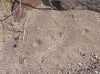 Feral cat prints in the sand of Palm Valley
Links to related images: Nearby. Proofs. Map.
Approximate location: 29.2090396881104N / 113.194969177246W.
 Dry waterfall in Palm Valley
Links to related images: Nearby. Proofs. Map.
Approximate location: 29.2097873687744N / 113.195487976074W.
 Don Fleming hiking in Palm Valley
Links to related images: Nearby. Proofs. Map.
Approximate location: 29.2097129821777N / 113.195915222168W.
 Mammiary cactus in Palm Valley
Links to related images: Nearby. Proofs. Map.
Approximate location: 29.2097873687744N / 113.196434020996W.
 Eliphant tree stump in Palm Valley
Links to related images: Nearby. Proofs. Map.
Approximate location: 29.2097873687744N / 113.196434020996W.
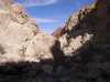 Palm valley continues for a long time with not more palm trees
Links to related images: Nearby. Proofs. Map.
Approximate location: 29.2100887298584N / 113.197372436523W.
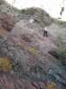 Don Fleming and John Somers climing a rock in Palm Valley
Links to related images: Nearby. Proofs. Map.
Approximate location: 29.2105369567871N / 113.197891235352W.
 John Weed and Doug Hamilton in Palm Valley
Links to related images: Nearby. Proofs. Map.
Approximate location: 29.2105369567871N / 113.198577880859W.

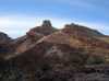

 John Weed calls this area the Color Room
Links to related images: Nearby. Proofs. Map.
Approximate location: 29.2118854522705N / 113.198745727539W.

 John Weed, Dave Harry and Don Fleming climbing down from the Color Room
Links to related images: Nearby. Proofs. Map.
Approximate location: 29.2118854522705N / 113.198745727539W.
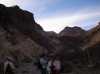
 Back to the mouth of Palm Valley to camp for the night
Links to related images: Nearby. Proofs. Map.
Approximate location: 29.2069416046143N / 113.172912597656W.
All text and images Copyright © 2006 by Mike Higgins / contact