The True Valley of the Palms, April 9th 2006.
Click on the small image to see the full-sized one.
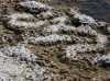
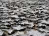
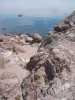
 Salt marsh margin at Punta Arena on Isla Angel de la Guarda
Links to related images: Nearby. Proofs. Map.
Approximate location: 29.193904876709N / 113.171798706055W.
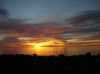
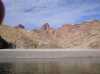
 Sunrise from Palm Valley
Links to related images: Nearby. Proofs. Map.
Approximate location: 29.2085151672363N / 113.171798706055W.
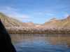
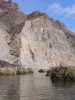
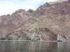
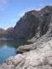
 Palm valley viewed from the water as I went for a day paddle
Links to related images: Nearby. Proofs. Map.
Approximate location: 29.2070903778076N / 113.171028137207W.
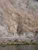
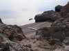
 Rocky point north of Palm Valley
Links to related images: Nearby. Proofs. Map.
Approximate location: 29.2165298461914N / 113.174201965332W.


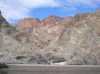
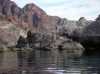
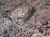
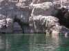
 Caves north of Palm Valley
Links to related images: Nearby. Proofs. Map.
Approximate location: 29.2199020385742N / 113.173942565918W.
 A small arch north of Palm Valley
Links to related images: Nearby. Proofs. Map.
Approximate location: 29.2225227355957N / 113.173515319824W.
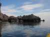
 My kayak laned near an arch on Isla Angel de la Guarda
Links to related images: Nearby. Proofs. Map.
Approximate location: 29.2225227355957N / 113.173515319824W.
 A large arroyo with no palm trees visible
Links to related images: Nearby. Proofs. Map.
Approximate location: 29.2258186340332N / 113.172401428223W.

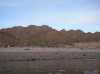
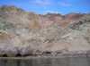
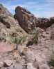
 How can there be a valley full of palm trees hidden in this steep terrain?
Links to related images: Nearby. Proofs. Map.
Approximate location: 29.2315120697021N / 113.175399780273W.
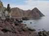
 Layers of rock in the cliff on Isla Angel de la Guarda
Links to related images: Nearby. Proofs. Map.
Approximate location: 29.234582901001N / 113.176605224609W.
 Great blue heron nests in a crack of the cliff
Links to related images: Nearby. Proofs. Map.
Approximate location: 29.2372035980225N / 113.176864624023W.
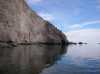
 Reflections of the cliffs in calm water
Links to related images: Nearby. Proofs. Map.
Approximate location: 29.2399005889893N / 113.177543640137W.
 From the map I thought there would be palms in this arroyo
Links to related images: Nearby. Proofs. Map.
Approximate location: 29.241548538208N / 113.178581237793W.
 Rock gardening up the coast of Isla Angel de la Guarda
Links to related images: Nearby. Proofs. Map.
Approximate location: 29.2443180084229N / 113.177803039551W.
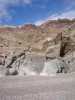
 Intruded rock layer in the cliff
Links to related images: Nearby. Proofs. Map.
Approximate location: 29.2470149993896N / 113.178062438965W.
 No palm trees visible in this steep arroyo
Links to related images: Nearby. Proofs. Map.
Approximate location: 29.2497863769531N / 113.177978515625W.
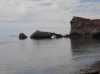
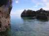
 Rocky shore of Isla Angel de la Guarda
Links to related images: Nearby. Proofs. Map.
Approximate location: 29.2500095367432N / 113.177719116211W.
 Rock gardening up the coast of Isla Angel de la Guarda
Links to related images: Nearby. Proofs. Map.
Approximate location: 29.2461166381836N / 113.177635192871W.
 No palm trees visible in this steep arroyo
Links to related images: Nearby. Proofs. Map.
Approximate location: 29.2461166381836N / 113.177635192871W.
 Reflections of the cliffs in calm water
Links to related images: Nearby. Proofs. Map.
Approximate location: 29.2487373352051N / 113.178062438965W.
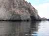 Caves in the cliffs of Isla Angel de la Guarda
Links to related images: Nearby. Proofs. Map.
Approximate location: 29.2487373352051N / 113.178062438965W.
 Light coming under the edge of a cave wall
Links to related images: Nearby. Proofs. Map.
Approximate location: 29.2487373352051N / 113.178062438965W.
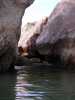
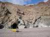
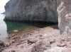
 Cave in the shore of Isla Angel de la Guarda
Links to related images: Nearby. Proofs. Map.
Approximate location: 29.2486991882324N / 113.178001403809W.
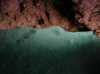
 Sting rays in the water inside a cave
Links to related images: Nearby. Proofs. Map.
Approximate location: 29.2466411590576N / 113.178062438965W.
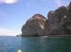
 A beautiful arch offshore of Isla Angel de la Guarda
Links to related images: Nearby. Proofs. Map.
Approximate location: 29.2521820068359N / 113.176948547363W.
 John Weed gave me a co-ordinate near here, but I see no palm trees
Links to related images: Nearby. Proofs. Map.
Approximate location: 29.253454208374N / 113.177635192871W.
 I climb up into the No Palm Arroyo anyway to check it out
Links to related images: Nearby. Proofs. Map.
Approximate location: 29.2533054351807N / 113.178489685059W.
 Isla Tiburon visible from No Palm Arroyo
Links to related images: Nearby. Proofs. Map.
Approximate location: 29.2533054351807N / 113.178489685059W.


 No palm trees found in No Palm Arroyo
Links to related images: Nearby. Proofs. Map.
Approximate location: 29.2516574859619N / 113.180549621582W.
 John Weed gave me another co-ordinate for this One Palm Arroyo
Links to related images: Nearby. Proofs. Map.
Approximate location: 29.2556266784668N / 113.177459716797W.
 Landed at One Palm Arroyo
Links to related images: Nearby. Proofs. Map.
Approximate location: 29.2556266784668N / 113.177635192871W.
 The small arch visible from One Palm Arroyo
Links to related images: Nearby. Proofs. Map.
Approximate location: 29.2556266784668N / 113.177635192871W.
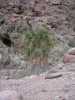
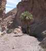
 Can you see one palm tree in this picture?
Links to related images: Nearby. Proofs. Map.
Approximate location: 29.2555522918701N / 113.177978515625W.
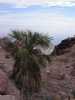 The one palm in one Palm Arroyo up close
Links to related images: Nearby. Proofs. Map.
Approximate location: 29.2551765441895N / 113.178749084473W.
 I don't spend much time in One Palm Arroyo
Links to related images: Nearby. Proofs. Map.
Approximate location: 29.2555522918701N / 113.178062438965W.
 My kayak below One Palm Arroyo
Links to related images: Nearby. Proofs. Map.
Approximate location: 29.2556266784668N / 113.177719116211W.
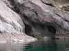
 A cave in the east shore of Isla Angel de la Guarda
Links to related images: Nearby. Proofs. Map.
Approximate location: 29.258996963501N / 113.177459716797W.
 Layers of rock in the east shore of Isla Angel de la Guarda
Links to related images: Nearby. Proofs. Map.
Approximate location: 29.2568244934082N / 113.177459716797W.
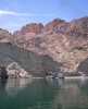
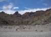
 A panga fishing camp near Punta Rocosa
Links to related images: Nearby. Proofs. Map.
Approximate location: 29.2638626098633N / 113.176345825195W.
 Punta Rocosa on Isla Angel de la Guarda
Links to related images: Nearby. Proofs. Map.
Approximate location: 29.269702911377N / 113.171882629395W.
 Caves in Punta Rocosa
Links to related images: Nearby. Proofs. Map.
Approximate location: 29.2744960784912N / 113.170082092285W.
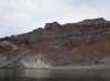
 Layers of rock in the cliffs of Isla Angel de la Guarda
Links to related images: Nearby. Proofs. Map.
Approximate location: 29.258996963501N / 113.177116394043W.
 I finally saw the palm trees from the water!
Links to related images: Nearby. Proofs. Map.
Approximate location: 29.2515087127686N / 113.177291870117W.


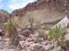
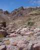
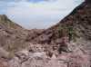
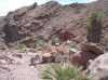
 I hiked up the real Valley of the Palms
Links to related images: Nearby. Proofs. Map.
Approximate location: 29.2500095367432N / 113.179092407227W.


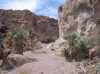
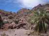
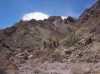
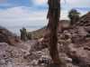
 Around every corner were more and more palm trees
Links to related images: Nearby. Proofs. Map.
Approximate location: 29.2507591247559N / 113.180892944336W.
 A 'torched' palm tree in front of a rock formation in the Valley of the Palms
Links to related images: Nearby. Proofs. Map.
Approximate location: 29.2507591247559N / 113.180892944336W.

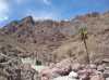
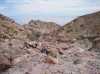
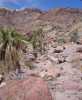 Around every corner were more and more palm trees
Links to related images: Nearby. Proofs. Map.
Approximate location: 29.2500095367432N / 113.182952880859W.
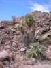
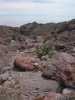
 Around every corner were more and more palm trees.
Links to related images: Nearby. Proofs. Map.
Approximate location: 29.2497100830078N / 113.184074401855W.
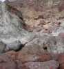
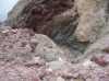
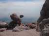
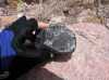 I'm told this is not high grade obsidian
Links to related images: Nearby. Proofs. Map.
Approximate location: 29.2500095367432N / 113.184501647949W.
 Around every corner were more and more palm trees
Links to related images: Nearby. Proofs. Map.
Approximate location: 29.2500095367432N / 113.185699462891W.
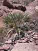
 Palm seeds collecting below the Mother Tree
Links to related images: Nearby. Proofs. Map.
Approximate location: 29.2500095367432N / 113.185699462891W.
 Around every corner were more and more palm trees
Links to related images: Nearby. Proofs. Map.
Approximate location: 29.2489624023438N / 113.186988830566W.
 I climed to 350 feet above sea level before the palm trees thined out
Links to related images: Nearby. Proofs. Map.
Approximate location: 29.2486629486084N / 113.187156677246W.

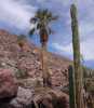
 The last palm tree in the Valley of the Palms
Links to related images: Nearby. Proofs. Map.
Approximate location: 29.2481384277344N / 113.18733215332W.


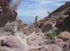
 I started climbing back down out of the Valley of the Palms
Links to related images: Nearby. Proofs. Map.
Approximate location: 29.2504596710205N / 113.184501647949W.


 Climbing back down out of the Valley of the Palms
Links to related images: Nearby. Proofs. Map.
Approximate location: 29.2498607635498N / 113.18286895752W.


 Climbing back down out of the Valley of the Palms.
Links to related images: Nearby. Proofs. Map.
Approximate location: 29.2503089904785N / 113.179946899414W.
 Climbing back down out of the Valley of the Palms
Links to related images: Nearby. Proofs. Map.
Approximate location: 29.2500858306885N / 113.179260253906W.

 Finally the water appeared again below the Valley of the Palms
Links to related images: Nearby. Proofs. Map.
Approximate location: 29.2515087127686N / 113.177459716797W.
 My kayak waiting for me below the Valley of the Palms
Links to related images: Nearby. Proofs. Map.
Approximate location: 29.2511329650879N / 113.177375793457W.
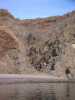
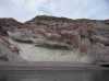
 Red cliffs above the water of Isla Angel de la Guarda
Links to related images: Nearby. Proofs. Map.
Approximate location: 29.2497863769531N / 113.177375793457W.
 I landed at the arroyo I thought would have palms
Links to related images: Nearby. Proofs. Map.
Approximate location: 29.2369041442871N / 113.177459716797W.
 View south from the wishful palm arroyo
Links to related images: Nearby. Proofs. Map.
Approximate location: 29.2369041442871N / 113.177459716797W.
 No palm trees but it would have been good camping
Links to related images: Nearby. Proofs. Map.
Approximate location: 29.2369041442871N / 113.177459716797W.
 A dry cave large enough to camp inside
Links to related images: Nearby. Proofs. Map.
Approximate location: 29.2337589263916N / 113.177459716797W.
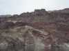
 Rocky point on the east shore of Isla Angel de la Guarda
Links to related images: Nearby. Proofs. Map.
Approximate location: 29.2249202728271N / 113.172569274902W.
 A small arch on the shore of Isla Angel de la Guarda
Links to related images: Nearby. Proofs. Map.
Approximate location: 29.2205753326416N / 113.173858642578W.
 Rock gardening down the coast of Isla Angel de la Guarda
Links to related images: Nearby. Proofs. Map.
Approximate location: 29.2196025848389N / 113.174026489258W.
 My tent in John's Palm Valley
Links to related images: Nearby. Proofs. Map.
Approximate location: 29.2064914703369N / 113.172828674316W.
All text and images Copyright © 2006 by Mike Higgins / contact