Isla Partida to Isla Salsipuedes, April 11th 2006.
Click on the small image to see the full-sized one.
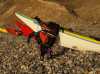
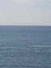
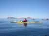
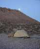
 The intrepid kayaker resting north of Isla Rasa
Links to related images: Nearby. Proofs. Map.
Approximate location: 28.8482818603516N / 113.000564575195W.
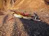
 Packing the kayaks in the morning on Isla Partida
Links to related images: Nearby. Proofs. Map.
Approximate location: 28.8909759521484N / 113.038848876953W.
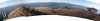
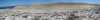
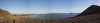 A panormama looking north from Isla Partida
Links to related images: Nearby. Proofs. Map.
Approximate location: 28.8909759521484N / 113.038848876953W.
 Looking west from Isla Partida
Links to related images: Nearby. Proofs. Map.
Approximate location: 28.8913516998291N / 113.039016723633W.
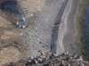
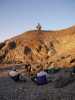
 Looking down at camp from above on Isla Partida
Links to related images: Nearby. Proofs. Map.
Approximate location: 28.8903732299805N / 113.039962768555W.
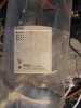
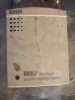 A data logger in an improvised shelter on Isla Partida
Links to related images: Nearby. Proofs. Map.
Approximate location: 28.8896217346191N / 113.040306091309W.
 Looking down at camp from above on Isla Partida
Links to related images: Nearby. Proofs. Map.
Approximate location: 28.8872184753418N / 113.042449951172W.
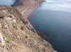
 View north east across most of Isla Partida
Links to related images: Nearby. Proofs. Map.
Approximate location: 28.8865413665771N / 113.042625427246W.
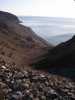
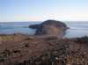
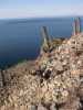
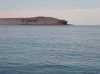
 The south end of Isla Partida has steep cliffs
Links to related images: Nearby. Proofs. Map.
Approximate location: 28.8844375610352N / 113.042366027832W.
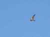 Some kind of falcon above Ilsa Partida
Links to related images: Nearby. Proofs. Map.
Approximate location: 28.8844375610352N / 113.042366027832W.
 View north east across most of Isla Partida
Links to related images: Nearby. Proofs. Map.
Approximate location: 28.8850383758545N / 113.041679382324W.
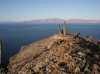
 View noth to Isla Angel de la Guarda from Isla Partida
Links to related images: Nearby. Proofs. Map.
Approximate location: 28.8850383758545N / 113.041679382324W.
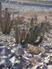
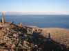
 Panorama from the southeast peak of Isla Partida
Links to related images: Nearby. Proofs. Map.
Approximate location: 28.8850383758545N / 113.041679382324W.
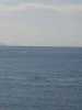
 View west to the Baja Penisula from Isla Partida
Links to related images: Nearby. Proofs. Map.
Approximate location: 28.8850383758545N / 113.041679382324W.
 View south to Islas Rasa, Salsipuedes, Animas and Lorenzo from Isla Partida
Links to related images: Nearby. Proofs. Map.
Approximate location: 28.8850383758545N / 113.041679382324W.
 View west to the Baja Penisula from Isla Partida
Links to related images: Nearby. Proofs. Map.
Approximate location: 28.8850383758545N / 113.041679382324W.
 The south end of Isla Partida has steep cliffs
Links to related images: Nearby. Proofs. Map.
Approximate location: 28.8860912322998N / 113.040992736816W.
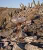
 I ran into Doug Hamilton hiking on Isla Partida
Links to related images: Nearby. Proofs. Map.
Approximate location: 28.8860912322998N / 113.040992736816W.
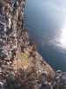 The south end of Isla Partida has steep cliffs
Links to related images: Nearby. Proofs. Map.
Approximate location: 28.8860912322998N / 113.040992736816W.
 Looking down at camp from above on Isla Partida
Links to related images: Nearby. Proofs. Map.
Approximate location: 28.8865413665771N / 113.041763305664W.
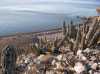
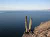
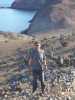
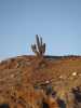
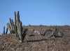 Cordone cactus and Doug Hamilton on top of Isla Partida
Links to related images: Nearby. Proofs. Map.
Approximate location: 28.8865413665771N / 113.041763305664W.
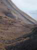
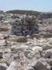
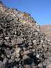 A basalt talus jumble on Isla Partida. Critters live between the rocks.
Links to related images: Nearby. Proofs. Map.
Approximate location: 28.8872184753418N / 113.042106628418W.

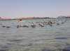
 Dolphins jumping off Isla Partida
Links to related images: Nearby. Proofs. Map.
Approximate location: 28.8883457183838N / 113.040214538574W.
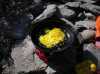 I brought chicken eggs for breakfast on Isla Partida
Links to related images: Nearby. Proofs. Map.
Approximate location: 28.8883457183838N / 113.040214538574W.
 Dolphins jumping off Isla Partida
Links to related images: Nearby. Proofs. Map.
Approximate location: 28.8866157531738N / 113.035499572754W.
 Dave Harry, John Somers and Doug Hamilton paddling away from Isla Partida
Links to related images: Nearby. Proofs. Map.
Approximate location: 28.8866157531738N / 113.035499572754W.


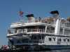 The cruise ship 'Sea Bird' anchored off Isla Rasa
Links to related images: Nearby. Proofs. Map.
Approximate location: 28.823299407959N / 112.984001159668W.
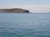
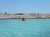
 Approaching the lagoon entrance to Isla Rasa
Links to related images: Nearby. Proofs. Map.
Approximate location: 28.823299407959N / 112.984001159668W.
 Dave Harry paddling in the Isla Rasa lagoon
Links to related images: Nearby. Proofs. Map.
Approximate location: 28.823299407959N / 112.984001159668W.
 The naturalist's house on Isla Rasa
Links to related images: Nearby. Proofs. Map.
Approximate location: 28.823299407959N / 112.984001159668W.
 John Somers paddling in the Isla Rasa lagoon
Links to related images: Nearby. Proofs. Map.
Approximate location: 28.823299407959N / 112.984001159668W.
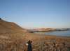
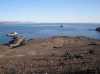
 Landed on Isla Rasa
Links to related images: Nearby. Proofs. Map.
Approximate location: 28.823299407959N / 112.984001159668W.
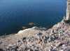
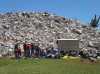 Eco-tourist birders from the cruise ship 'Sea Bird' prepare for a tour of Isla Rasa
Links to related images: Nearby. Proofs. Map.
Approximate location: 28.823299407959N / 112.984001159668W.
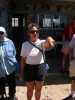 Enriqueta, the resident naturalist on Isla Rasa
Links to related images: Nearby. Proofs. Map.
Approximate location: 28.823299407959N / 112.984001159668W.

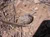 Herman's gull eggs on the side of the trail on Isla Rasa
Links to related images: Nearby. Proofs. Map.
Approximate location: 28.823299407959N / 112.984001159668W.
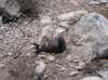 The Herman's gulls have no fear of humans on Isla Rasa
Links to related images: Nearby. Proofs. Map.
Approximate location: 28.823299407959N / 112.984001159668W.
 Birds and 'Mysterious cairns' on Isla Rasa
Links to related images: Nearby. Proofs. Map.
Approximate location: 28.823299407959N / 112.984001159668W.
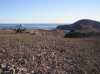
 A dried up lagoon on Isla Rasa is now a nesting area for gulls and terns
Links to related images: Nearby. Proofs. Map.
Approximate location: 28.823299407959N / 112.984001159668W.
 The tern colony on Isla Rasa
Links to related images: Nearby. Proofs. Map.
Approximate location: 28.8233337402344N / 112.984169006348W.

 A pair of gulls mating in front of one of the 'mysterious cairns' on Isla Rasa
Links to related images: Nearby. Proofs. Map.
Approximate location: 28.8233337402344N / 112.984169006348W.
 A picture of eco-tourists taking my picture
Links to related images: Nearby. Proofs. Map.
Approximate location: 28.8233337402344N / 112.984169006348W.
 A raven watches us set up camp on Isla Salsipuedes
Links to related images: Nearby. Proofs. Map.
Approximate location: 28.7289791107178N / 112.956100463867W.
 Relaxing at camp on the north end of Isla Salsipuedes
Links to related images: Nearby. Proofs. Map.
Approximate location: 28.7289791107178N / 112.956100463867W.
 The moon rises over our camp on Isla Salsipuedes
Links to related images: Nearby. Proofs. Map.
Approximate location: 28.7289791107178N / 112.956100463867W.
All text and images Copyright © 2006 by Mike Higgins / contact