Isla San Lorenzo to the Baja Desert, April 13th 2006.
Click on the small image to see the full-sized one.
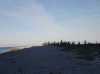
 Doug Hamilton and I landed back on the Baja Peninsula
Links to related images: Nearby. Proofs. Map.
Approximate location: 28.460994720459N / 112.886070251465W.
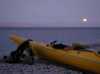 Moonset on Isla san Lorenzo in the morning
Links to related images: Nearby. Proofs. Map.
Approximate location: 28.5871601104736N / 112.785385131836W.
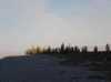
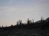 The sun finally touching the cardone forest on Isla san Lorenzo
Links to related images: Nearby. Proofs. Map.
Approximate location: 28.5871601104736N / 112.785385131836W.
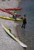
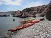
 Getting ready to launch from Isla san Lorenzo
Links to related images: Nearby. Proofs. Map.
Approximate location: 28.5871601104736N / 112.785385131836W.
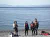
 Landed for a break on the Baja Peninsula, we could walk home from here!
Links to related images: Nearby. Proofs. Map.
Approximate location: 28.4617881774902N / 112.885444641113W.
 Isla san Lorenzo behind rock gardens on Punta Ballena
Links to related images: Nearby. Proofs. Map.
Approximate location: 28.4617881774902N / 112.885444641113W.

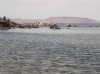
 We ran into Alberto in a panga in San Francisquito Bay
Links to related images: Nearby. Proofs. Map.
Approximate location: 28.4497318267822N / 112.873710632324W.
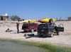 Loading all the gear back into the trucks for the return home
Links to related images: Nearby. Proofs. Map.
Approximate location: 28.4254665374756N / 112.864868164062W.
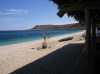 Stopping at the San Francisquito Resort for lunch before the long drive home
Links to related images: Nearby. Proofs. Map.
Approximate location: 28.4098415374756N / 112.857894897461W.
All text and images Copyright © 2006 by Mike Higgins / contact