Neah Bay to Cape Flattery, August 7th 2006.
Click on the small image to see the full-sized one.
 Roger Lamb packing for the start of the Washington Coast Trip
Links to related images: Nearby. Proofs. Map.
Approximate location: 48.3687934875488N / 124.601181030273W.

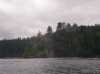
 Rounding Weadah Island as we leave Neah Bay
Links to related images: Nearby. Proofs. Map.
Approximate location: 48.3866386413574N / 124.601524353027W.


 Starting around Cape Flattery
Links to related images: Nearby. Proofs. Map.
Approximate location: 48.3902282714844N / 124.71671295166W.
 First knotch in Cape Flattery
Links to related images: Nearby. Proofs. Map.
Approximate location: 48.3896026611328N / 124.717826843262W.
 Roger Lamb in front of rocks off Cape Flattery
Links to related images: Nearby. Proofs. Map.
Approximate location: 48.3900032043457N / 124.718940734863W.

 Vertical cliffs of Cape Flattery
Links to related images: Nearby. Proofs. Map.
Approximate location: 48.3897171020508N / 124.721176147461W.

 First arch through the cliffs of Cape Flattery
Links to related images: Nearby. Proofs. Map.
Approximate location: 48.3898887634277N / 124.71842956543W.
 Landed for lunch in a knotch in Cape Flattery
Links to related images: Nearby. Proofs. Map.
Approximate location: 48.3874359130859N / 124.720832824707W.
 Roger in a fijord in Cape Flattery
Links to related images: Nearby. Proofs. Map.
Approximate location: 48.3878936767578N / 124.721603393555W.
 Big cave/arch in Cape Flattery
Links to related images: Nearby. Proofs. Map.
Approximate location: 48.3879508972168N / 124.723487854004W.
 View of Tatoosh Island from Cape Flattery
Links to related images: Nearby. Proofs. Map.
Approximate location: 48.3882904052734N / 124.724090576172W.
 Cliff with viewing plaform on Cape Flattery
Links to related images: Nearby. Proofs. Map.
Approximate location: 48.3870391845703N / 124.725547790527W.
 Roger Lamb in front of steep shore of Cape Flattery
Links to related images: Nearby. Proofs. Map.
Approximate location: 48.3869247436523N / 124.725036621094W.
 Tatoosh Island Lighthouse viewed from a cave on Cape Flattery
Links to related images: Nearby. Proofs. Map.
Approximate location: 48.3866386413574N / 124.724006652832W.

 Looking out a cave on Cape Flattery
Links to related images: Nearby. Proofs. Map.
Approximate location: 48.3866386413574N / 124.724006652832W.
 Double entrance cave on Cape Flattery
Links to related images: Nearby. Proofs. Map.
Approximate location: 48.3866386413574N / 124.724006652832W.
 We met Kari Anderson of Azimuth Expeditions on the water.
Links to related images: Nearby. Proofs. Map.
Approximate location: 48.3860130310059N / 124.725036621094W.

 Cape Flattery is riddled with caves and arches
Links to related images: Nearby. Proofs. Map.
Approximate location: 48.3844146728516N / 124.725463867188W.
 Some caves connected to take us completely through some points
Links to related images: Nearby. Proofs. Map.
Approximate location: 48.3837890625N / 124.725296020508W.


 Sea stacks have trees on them in the Pacific Northwest
Links to related images: Nearby. Proofs. Map.
Approximate location: 48.3825912475586N / 124.730186462402W.

 We paddled across to Tatoosh Island
Links to related images: Nearby. Proofs. Map.
Approximate location: 48.3902282714844N / 124.73713684082W.
 Roger in front of Tatoosh Island
Links to related images: Nearby. Proofs. Map.
Approximate location: 48.3910865783691N / 124.737739562988W.
 Vancouver Island viewed from behind Tatoosh Island
Links to related images: Nearby. Proofs. Map.
Approximate location: 48.3929672241211N / 124.74040222168W.
 Tatoosh Island, lighthouse and Cape Flattery behind them.
Links to related images: Nearby. Proofs. Map.
Approximate location: 48.3938789367676N / 124.739540100098W.
 A channel into the center of Tatoosh Island
Links to related images: Nearby. Proofs. Map.
Approximate location: 48.3930816650391N / 124.737823486328W.
 We land in the center of Tatoosh Island
Links to related images: Nearby. Proofs. Map.
Approximate location: 48.3924522399902N / 124.736968994141W.
 Tatoosh Island is a nesting area for gulls
Links to related images: Nearby. Proofs. Map.
Approximate location: 48.3924522399902N / 124.736968994141W.
 Cove on Tatoosh Island
Links to related images: Nearby. Proofs. Map.
Approximate location: 48.3923950195312N / 124.736450195312W.
 Old Coast Guard landing on Tatoosh Island
Links to related images: Nearby. Proofs. Map.
Approximate location: 48.3923950195312N / 124.736450195312W.
 The gulls nesting on Tatoosh Island make it a noisy and dirty place
Links to related images: Nearby. Proofs. Map.
Approximate location: 48.3923950195312N / 124.736450195312W.
 Launching and continuing around Tatoosh Island
Links to related images: Nearby. Proofs. Map.
Approximate location: 48.3944473266602N / 124.739112854004W.
 The Lighthouse on Tatoosh Island
Links to related images: Nearby. Proofs. Map.
Approximate location: 48.3950729370117N / 124.737739562988W.
 Tatoosh Island rocks
Links to related images: Nearby. Proofs. Map.
Approximate location: 48.394905090332N / 124.736106872559W.
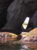
 Stellar's sea liona on a rock near Tatoosh Island
Links to related images: Nearby. Proofs. Map.
Approximate location: 48.3945045471191N / 124.735847473145W.
 Tatoosh Island lighthouse
Links to related images: Nearby. Proofs. Map.
Approximate location: 48.3941040039062N / 124.735336303711W.

 Old Coast Guard loading crane on Tatoosh Island
Links to related images: Nearby. Proofs. Map.
Approximate location: 48.3929100036621N / 124.735160827637W.
 Old Coast Guard loading beach on Tatoosh Island
Links to related images: Nearby. Proofs. Map.
Approximate location: 48.3925666809082N / 124.735847473145W.
 Cave through the middle of Tatoosh Island
Links to related images: Nearby. Proofs. Map.
Approximate location: 48.3925666809082N / 124.735679626465W.
 Sea stack off Tatoosh Island
Links to related images: Nearby. Proofs. Map.
Approximate location: 48.3930244445801N / 124.733703613281W.


 Cave through Tatoosh Island
Links to related images: Nearby. Proofs. Map.
Approximate location: 48.3925094604492N / 124.734130859375W.

 Tatoosh Island lighthouse throuh an arch on Cape Flattery
Links to related images: Nearby. Proofs. Map.
Approximate location: 48.385555267334N / 124.725463867188W.


 Our camping beach on Cape Flattery
Links to related images: Nearby. Proofs. Map.
Approximate location: 48.3842468261719N / 124.723487854004W.

 A frog came to visit our camp on Cape Flattery
Links to related images: Nearby. Proofs. Map.
Approximate location: 48.3842468261719N / 124.723487854004W.

 Our camp on Cape Flattery late in the day
Links to related images: Nearby. Proofs. Map.
Approximate location: 48.3845863342285N / 124.723579406738W.
 The sunset was visible throuh a cave we walked into at low tide
Links to related images: Nearby. Proofs. Map.
Approximate location: 48.3842468261719N / 124.724266052246W.
 Roger Lamb in campl at Cape Flattery
Links to related images: Nearby. Proofs. Map.
Approximate location: 48.3843574523926N / 124.723663330078W.
All text and images Copyright © 2006 by Mike Higgins / contact