Point Lobos State Reserve, January 28th 2007.
Click on the small image to see the full-sized one.
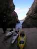
 The calm spot at the south end of Monastery Beach
Links to related images: Nearby. Proofs. Map.
Approximate location: 36.523052965845N / 121.92893028259W.
 Launching from the middle of Monastery Beach
Links to related images: Nearby. Proofs. Map.
Approximate location: 36.5233288655154N / 121.92850112915W.
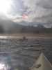
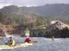
 Everyone launched off Monastery Beach
Links to related images: Nearby. Proofs. Map.
Approximate location: 36.5232254032543N / 121.92940235138W.
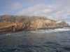
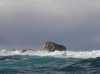
 Waves washing over Granite Point
Links to related images: Nearby. Proofs. Map.
Approximate location: 36.5243979674449N / 121.934466362W.

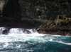
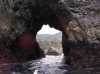
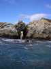
 A cave through one of the Bird Rocks of Point Lobos State Reserve
Links to related images: Nearby. Proofs. Map.
Approximate location: 36.5073423055793N / 121.94212675095W.


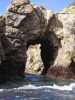
 A slot through one of the Bird Rocks of Point Lobos State Reserve
Links to related images: Nearby. Proofs. Map.
Approximate location: 36.5075406488289N / 121.94230914116W.

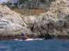
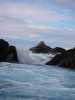 Rough waves through a slot on Point Lobos State Reserve
Links to related images: Nearby. Proofs. Map.
Approximate location: 36.5085582279437N / 121.94213747978W.
 The unnamed scofflaw illegally landed on Point Lobos State Reserve
Links to related images: Nearby. Proofs. Map.
Approximate location: 36.5080063222873N / 121.94102168083W.
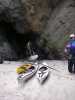
 Landing in the portage-through-cave
Links to related images: Nearby. Proofs. Map.
Approximate location: 36.507467348122N / 121.94106996059W.
 Don Barch in the portage-through-cave
Links to related images: Nearby. Proofs. Map.
Approximate location: 36.507467348122N / 121.94109678268W.
 The way out the other end of the portage-through-cave
Links to related images: Nearby. Proofs. Map.
Approximate location: 36.5073509292095N / 121.94092512131W.
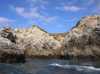
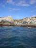
 More caves and arches in the Bird Rock area of Point Lobos
Links to related images: Nearby. Proofs. Map.
Approximate location: 36.5067860794075N / 121.94098949432W.
 John Somers and Ruth Cooper hiking the cliffs of Point Lobos
Links to related images: Nearby. Proofs. Map.
Approximate location: 36.5065446156392N / 121.94118797779W.
 Doug Hmilton padding Point Lobos
Links to related images: Nearby. Proofs. Map.
Approximate location: 36.5064238834726N / 121.94133281708W.
 Donna Fabiano, Kate andDoug Hmilton padding Point Lobos
Links to related images: Nearby. Proofs. Map.
Approximate location: 36.5062341611161N / 121.94145619869W.
 The calmer water outside Devils Cauldron (really, we went inside this)
Links to related images: Nearby. Proofs. Map.
Approximate location: 36.5164655690526N / 121.95787668228W.
All text and images Copyright © 2007 by Mike Higgins / contact