San Lucas to Isla San Marcos, March 27th
Click on the small image to see the full-sized one.
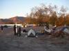
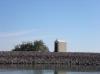
 Our starting campsite, the RV park in San Lucas, Baja California
Links to related images: Nearby. Proofs. Map.
Approximate location: 27.2172354248002N / 112.21426963806W.
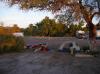
 My kayak ready to launch at San Lucas, Baja California
Links to related images: Nearby. Proofs. Map.
Approximate location: 27.2173117521884N / 112.21409797668W.
 Doug Hamilton in the lead as we launch from San Lucas, Baja California
Links to related images: Nearby.
Approximate location: 27.2160905077021N / 112.21186637878W.
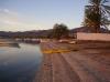
 A shrine on the spit at the mouth of the San Lucas Harbor
Links to related images: Nearby.
Approximate location: 27.2082284258559N / 112.20448493958W.
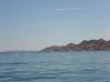
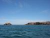
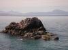
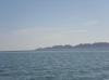 Our goal for the evening, the north end of Isla San Marcos
Links to related images: Nearby.
Approximate location: 27.2061674000174N / 112.20302581787W.
 Kate DesLauriers doing a stretch with her paddle in the San Lucas Harbor
Links to related images: Nearby.
Approximate location: 27.2067780783134N / 112.20362663269W.
 Doug Hamilton with Isla San Marcos behind him
Links to related images: Nearby.
Approximate location: 27.2108237375082N / 112.19478607178W.
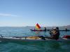
 Don tipping his hat to the crossing to Isla San Marcos
Links to related images: Nearby.
Approximate location: 27.2146402624869N / 112.18465805054W.
 Andrea Wolf crossing to Isla San Marcos
Links to related images: Nearby. Proofs. Map.
Approximate location: 27.2186093097862N / 112.17761993408W.
 Kate DesLauriers crossing to Isla San Marcos
Links to related images: Nearby. Proofs. Map.
Approximate location: 27.2237993890333N / 112.16869354248W.
 Kate DesLauriers et al crossing to Isla San Marcos
Links to related images: Nearby.
Approximate location: 27.2262416955827N / 112.16526031494W.
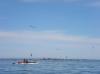
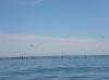 Birds diving on a bait ball near Isla San Marcos
Links to related images: Nearby. Proofs. Map.
Approximate location: 27.2331103955759N / 112.13573455811W.
 Kate DesLauriers crossing to Isla San Marcos
Links to related images: Nearby. Proofs. Map.
Approximate location: 27.2343314534349N / 112.1350479126W.
 Kate DesLauriers photographing birds diving on a bait ball near Isla San Marcos
Links to related images: Nearby. Proofs. Map.
Approximate location: 27.2353235530835N / 112.12560653687W.
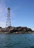
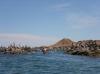
 Doug Hamilton under the faro on Isla San Marcos
Links to related images: Nearby. Proofs. Map.
Approximate location: 27.2368498429697N / 112.10904121399W.

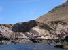
 Rock gardening up the west shore of Isla San Marcos
Links to related images: Nearby. Proofs. Map.
Approximate location: 27.245167754986N / 112.10217475891W.
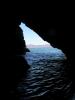
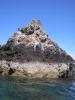
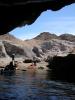
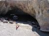
 My first cave of the trip! On the west shore of Isla San Marcos
Links to related images: Nearby. Proofs. Map.
Approximate location: 27.2452440632274N / 112.10208892822W.
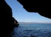
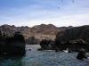
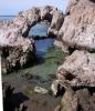
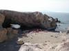
 Arch to a cobble beach on the west shore of Isla San Marcos
Links to related images: Nearby. Proofs. Map.
Approximate location: 27.2483726560641N / 112.10217475891W.
 Rock gardening up the west shore of Isla San Marcos
Links to related images: Nearby. Proofs. Map.
Approximate location: 27.2486778799234N / 112.10131645203W.
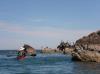
 Osprey nest on the west shore of Isla San Marcos
Links to related images: Nearby. Proofs. Map.
Approximate location: 27.2488304915391N / 112.10140228271W.
 Rock gardening up the west shore of Isla San Marcos
Links to related images: Nearby. Proofs. Map.
Approximate location: 27.2489831029454N / 112.10208892822W.
 Kate DesLauriers follows Don into an arch that leads to a beach
Links to related images: Nearby. Proofs. Map.
Approximate location: 27.25089072786N / 112.09668159485W.
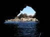
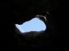 The arch has a skylight in the ceiling showing a contrail
Links to related images: Nearby. Proofs. Map.
Approximate location: 27.25089072786N / 112.09668159485W.
 Herb Howe landing at the beach inside the arch on Isla San Marcos
Links to related images: Nearby. Proofs. Map.
Approximate location: 27.2510433364401N / 112.09650993347W.
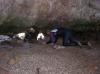 Doug Hamilton goes spelunking through a smaller arch
Links to related images: Nearby. Proofs. Map.
Approximate location: 27.2510433364401N / 112.09650993347W.
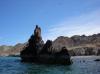
 Don Fleming snorkeling at Isla San Marcos
Links to related images: Nearby. Proofs. Map.
Approximate location: 27.2510433364401N / 112.09650993347W.
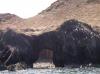
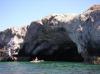
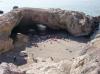
 Beautiful smaller arch on Isla San Marcos
Links to related images: Nearby. Proofs. Map.
Approximate location: 27.25089072786N / 112.09659576416W.
 Don Fleming snorkeling at Isla San Marcos
Links to related images: Nearby. Proofs. Map.
Approximate location: 27.25089072786N / 112.09659576416W.
 Kate DesLariers from above on Isla San Marcos
Links to related images: Nearby. Proofs. Map.
Approximate location: 27.25089072786N / 112.09659576416W.
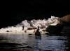
 Our kayaks laned under the arch on Isla San Marcos
Links to related images: Nearby. Proofs. Map.
Approximate location: 27.24905940857N / 112.09659576416W.
 Andrea Wolf from above on Isla San Marcos
Links to related images: Nearby. Proofs. Map.
Approximate location: 27.251348552972N / 112.09573745728W.
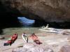
 Our camsite behind the arch on Isla San Marcos
Links to related images: Nearby. Proofs. Map.
Approximate location: 27.2505855100719N / 112.09642410278W.
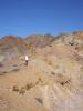 Doug Hamilton on a hike up to the top of Isla San Marcos
Links to related images: Nearby. Proofs. Map.
Approximate location: 27.2508144234915N / 112.09342002869W.
 Andrea Wolf on a hike up to the top of Isla San Marcos
Links to related images: Nearby. Proofs. Map.
Approximate location: 27.2508144234915N / 112.09342002869W.

 Doug Hamilton on a hike up to the top of Isla San Marcos
Links to related images: Nearby. Proofs. Map.
Approximate location: 27.2508144234915N / 112.09342002869W.
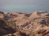
 Our campsite viewed from the top of Isla San Marcos
Links to related images: Nearby. Proofs. Map.
Approximate location: 27.2511196406516N / 112.093334198W.
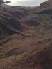
 Another sandy beach viewed from the top of Isla San Marcos
Links to related images: Nearby. Proofs. Map.
Approximate location: 27.2510433364401N / 112.09324836731W.

 Doug Hamilton on the top of Isla San Marcos
Links to related images: Nearby. Proofs. Map.
Approximate location: 27.2509670321762N / 112.093334198W.

 The intrepid kayaker on the top of Isla San Marcos
Links to related images: Nearby. Proofs. Map.
Approximate location: 27.2509670321762N / 112.093334198W.
 A panga fish camp viewed from the top of Isla San Marcos
Links to related images: Nearby. Proofs. Map.
Approximate location: 27.2510433364401N / 112.09316253662W.
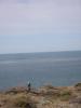
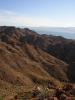 A view south from the top of Isla San Marcos
Links to related images: Nearby. Proofs. Map.
Approximate location: 27.2509670321762N / 112.09316253662W.
 A view north from the top of Isla San Marcos
Links to related images: Nearby. Proofs. Map.
Approximate location: 27.25039N / 112.09664W.
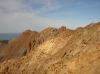
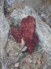 A REALLY, REALLY, RED rock on Isla San Marcos
Links to related images: Nearby. Proofs. Map.
Approximate location: 27.2509670321762N / 112.09436416626W.

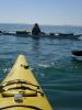
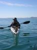
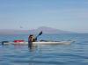
 The intrepid kayaker paddling out of San Lucas, Baja
Links to related images: Nearby.
Approximate location: 27.21436N / 112.2091W.
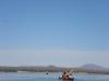
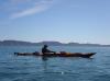
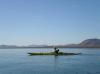
 The intrepid kayaker paddling towards Isla San Marcos
Links to related images: Nearby.
Approximate location: 27.21715N / 112.1524W.
All text and images Copyright © 2007 by Mike Higgins / contact