Isla San Marcos to Punta Cacareo, March 29th 2007.
Click on the small image to see the full-sized one.
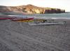
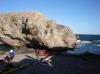 Don Fleming and Kate DesLauriers getting ready to launch
Links to related images: Nearby. Proofs. Map.
Approximate location: 27.24981N / 112.10273W.
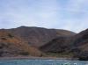
 Kate DesLauriers paddling past the west shore of Isla San Marcos
Links to related images: Nearby. Proofs. Map.
Approximate location: 27.22721N / 112.10057W.
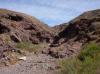
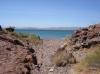
 Roads visible from the west shore of Isla San Marcos
Links to related images: Nearby. Proofs. Map.
Approximate location: 27.20558N / 112.08705W.
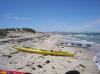
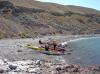 Landed for a break on the west shore of Isla San Marcos
Links to related images: Nearby. Proofs. Map.
Approximate location: 27.20586N / 112.08563W.
 Roads visible from the west shore of Isla San Marcos
Links to related images: Nearby. Proofs. Map.
Approximate location: 27.20586N / 112.08563W.

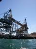
 The gypsum mining town on the south end of Isla San Marcos
Links to related images: Nearby. Proofs. Map.
Approximate location: 27.19093N / 112.08722W.
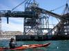
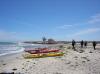
 Doug Hamilton in front of the fishing fleet behind Isla San Marcos
Links to related images: Nearby. Proofs. Map.
Approximate location: 27.17318N / 112.07415W.

 Isla San Rafael near Isla San Marcos
Links to related images: Nearby. Proofs. Map.
Approximate location: 27.16464N / 112.06767W.
 Doug Hamilton and Don Fleming at the Estero San Marcos
Links to related images: Nearby. Proofs. Map.
Approximate location: 27.12409N / 112.05529W.
 Our kayaks landed for lunch at the Estero San Marcos
Links to related images: Nearby. Proofs. Map.
Approximate location: 27.12409N / 112.05529W.
 Shell beach material at Estero San Marcos
Links to related images: Nearby. Proofs. Map.
Approximate location: 27.12409N / 112.05529W.
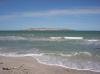 Isla San Marcos viewd from the Estero San Marcos
Links to related images: Nearby. Proofs. Map.
Approximate location: 27.12409N / 112.05529W.
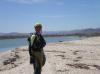
 Kate Deslauriers near the Estero San Marcos
Links to related images: Nearby. Proofs. Map.
Approximate location: 27.12409N / 112.05529W.
 Don Fleming at Punta Cacareo, near Punta Chivato
Links to related images: Nearby. Proofs. Map.
Approximate location: 27.07611N / 111.94865W.
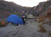
 Our kayaks parked for the night at Punta Cacareo
Links to related images: Nearby. Proofs. Map.
Approximate location: 27.07611N / 111.94865W.
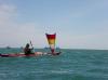
 The intrepid kayaker at the mouth of Estero San Marcos
Links to related images: Nearby. Proofs. Map.
Approximate location: 27.12349N / 112.05578W.
All text and images Copyright © 2007 by Mike Higgins / contact