Arroyo Verde to Punta Pulpito, April 4th 2007.
Click on the small image to see the full-sized one.
 People staying at the 'Private Cove' of San Sebastian
Links to related images: Nearby. Proofs. Map.
Approximate location: 26.61676N / 111.56382W.
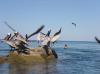
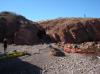
 Panga fishing camp south of San Sebastian
Links to related images: Nearby.
Approximate location: 26.58717N / 111.56719W.
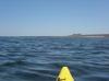
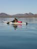 Kate DesLauriers in calm water heading for San Nicolas
Links to related images: Nearby.
Approximate location: 26.58065N / 111.56558W.
 Doug Hamilton in calm water heading for San Nicolas
Links to related images: Nearby.
Approximate location: 26.5567N / 111.55468W.
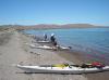
 We landed and waked into the town San Nicolas to buy water
Links to related images: Nearby.
Approximate location: 26.54846N / 111.54968W.
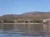
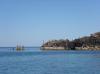
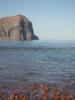
 Approaching Punta San Antonio with Punta El Pulpito behind
Links to related images: Nearby.
Approximate location: 26.53754N / 111.51666W.
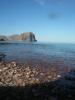
 Punta San Antonio
Links to related images: Nearby. Proofs. Map.
Approximate location: 26.53741N / 111.46394W.
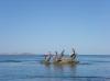
 Don Flemming between pelicans and Isla San Idelfonzo
Links to related images: Nearby. Proofs. Map.
Approximate location: 26.53786N / 111.46349W.
 Punta San Antonio
Links to related images: Nearby. Proofs. Map.
Approximate location: 26.53827N / 111.46231W.
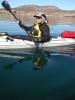
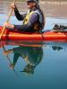
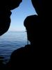 Self portrait of the intrepid kayaker in a cave, Isla San Idelfonzo distant
Links to related images: Nearby. Proofs. Map.
Approximate location: 26.53728N / 111.46153W.
 Doug Hamilton at Punta San Antonio with Punta El Pulpito behind
Links to related images: Nearby. Proofs. Map.
Approximate location: 26.53788N / 111.46031W.
 Doug Hamilton and Kate DesLauriers at Punta San Antonio
Links to related images: Nearby. Proofs. Map.
Approximate location: 26.53675N / 111.45924W.

 Don Fleming in front of Punta el Pulpito
Links to related images: Nearby. Proofs. Map.
Approximate location: 26.53675N / 111.45924W.
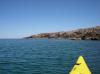
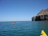
 Approaching Punta El Pulpito
Links to related images: Nearby. Proofs. Map.
Approximate location: 26.52411N / 111.45117W.
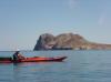
 Kate DesLauriers approaching Punta El Pulpito
Links to related images: Nearby. Proofs. Map.
Approximate location: 26.52102N / 111.44808W.
 Osprey nest on Punta El Pulpito
Links to related images: Nearby. Proofs. Map.
Approximate location: 26.52102N / 111.44808W.
 Everyone enjoying calm water in front of Punta El Pulpito
Links to related images: Nearby. Proofs. Map.
Approximate location: 26.52117N / 111.44761W.
 Doug Hamilton in front of Punta El Pulpito
Links to related images: Nearby. Proofs. Map.
Approximate location: 26.52117N / 111.44761W.
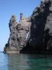
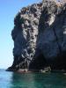
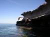
 Vertical cliffs of Punta El Pulpito
Links to related images: Nearby. Proofs. Map.
Approximate location: 26.5208N / 111.44643W.
 Doug Hamilton in front of Punta El Pulpito
Links to related images: Nearby. Proofs. Map.
Approximate location: 26.52059N / 111.44628W.

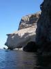
 Vertical cliffs of Punta El Pulpito
Links to related images: Nearby. Proofs. Map.
Approximate location: 26.51947N / 111.44407W.
 Don Fleming approaching big arch in Punta El Pulpito
Links to related images: Nearby. Proofs. Map.
Approximate location: 26.51868N / 111.44295W.
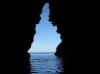
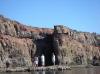
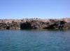
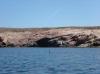
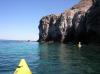
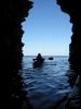
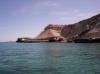
 Inside the big arch in Punta El Pulpito
Links to related images: Nearby. Proofs. Map.
Approximate location: 26.51808N / 111.44239W.
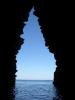
 Doug Hamilton through the big arch in Punta El Pulpito
Links to related images: Nearby. Proofs. Map.
Approximate location: 26.51808N / 111.44239W.
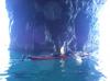
 Kate DesLauriers through the big arch in Punta El Pulpito
Links to related images: Nearby. Proofs. Map.
Approximate location: 26.51808N / 111.44239W.
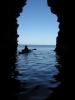
 Andrea Wolf through the big arch in Punta El Pulpito
Links to related images: Nearby. Proofs. Map.
Approximate location: 26.51638N / 111.44102W.
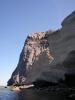
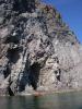
 Vertical cliffs of Punta El Pulpito
Links to related images: Nearby. Proofs. Map.
Approximate location: 26.5178N / 111.44201W.
 Doug Hamilton rounding Punta El Pulpito
Links to related images: Nearby. Proofs. Map.
Approximate location: 26.51662N / 111.44272W.
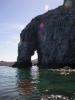 Elephant trunk arch on Punta El Pulpito
Links to related images: Nearby. Proofs. Map.
Approximate location: 26.51615N / 111.4431W.

 Doug Hamilton in front of elephant trunk arch on Punta El Pulpito
Links to related images: Nearby. Proofs. Map.
Approximate location: 26.51499N / 111.44546W.

 Sandstone cliffs in the cove south of Punta El Pulpito
Links to related images: Nearby. Proofs. Map.
Approximate location: 26.51387N / 111.45229W.
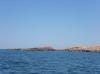
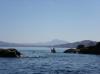
 Looking back at Punta El Pulpito
Links to related images: Nearby. Proofs. Map.
Approximate location: 26.51383N / 111.45231W.
 Red offshore rock south of Punta El Pulpito
Links to related images: Nearby. Proofs. Map.
Approximate location: 26.51059N / 111.45329W.
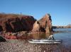
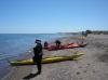
 Landing for the evening just south of Punta El Pulpito
Links to related images: Nearby. Proofs. Map.
Approximate location: 26.50857N / 111.45317W.
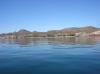
 Punta El Pulpito viewed from our camping beach
Links to related images: Nearby. Proofs. Map.
Approximate location: 26.50857N / 111.45317W.
 The intrepid kayaker paddling towards Punta El Pulpito
Links to related images: Nearby. Proofs. Map.
Approximate location: 26.53074N / 111.45467W.
All text and images Copyright © 2007 by Mike Higgins / contact