Layover Day to Isla Idelfonzo, April 5th 2007.
Click on the small image to see the full-sized one.

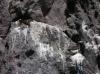
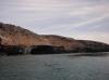
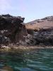
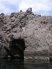
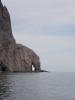
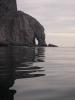 Punta El Pulpito and the elephant trunk arch in the moring
Links to related images: Nearby. Proofs. Map.
Approximate location: 26.51392N / 111.44495W.

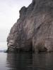
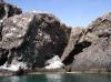
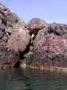
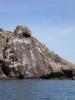
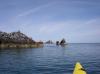
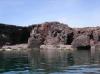
 The big arch in Punta El Pulpito
Links to related images: Nearby. Proofs. Map.
Approximate location: 26.5181N / 111.4422W.
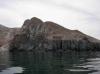
 Isla San Idelfonzo viewed from the big arch in Punta El Pulpito
Links to related images: Nearby. Proofs. Map.
Approximate location: 26.51814N / 111.4425W.
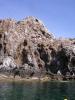
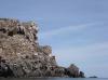
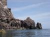
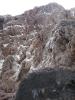
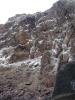
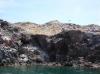
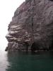
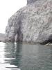
 Vertical cliffs of Punta El Pulpito
Links to related images: Nearby. Proofs. Map.
Approximate location: 26.51969N / 111.4422W.


 Dolphins escorted me for a few minutes of my crossing to Isla San Idelfonzo
Links to related images: Nearby. Proofs. Map.
Approximate location: 26.52194N / 111.44181W.
 Looking back at Punta El Pulpito
Links to related images: Nearby. Proofs. Map.
Approximate location: 26.55325N / 111.43291W.
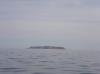
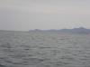
 Looking ahead to Isla San Idelfonzo
Links to related images: Nearby. Proofs. Map.
Approximate location: 26.60614N / 111.43162W.


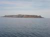
 First close approach to Isla San Idelfonzo
Links to related images: Nearby. Proofs. Map.
Approximate location: 26.6238N / 111.43003W.


 The new and old light on Isla San Idelfonzo
Links to related images: Nearby. Proofs. Map.
Approximate location: 26.62477N / 111.4272W.
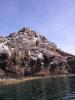
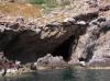
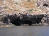
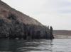
 Isla San Idelfonzo has many scary looking caves above the waterline
Links to related images: Nearby. Proofs. Map.
Approximate location: 26.62504N / 111.42667W.
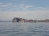
 Punta El Pulpito viewed from Isla San Idelfonzo
Links to related images: Nearby. Proofs. Map.
Approximate location: 26.62502N / 111.42602W.
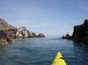
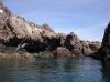
 Rock gardening around Isla San Idelfonzo
Links to related images: Nearby. Proofs. Map.
Approximate location: 26.62629N / 111.42465W.

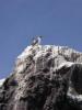
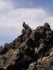
 Boobies on Isla San Idelfonzo
Links to related images: Nearby. Proofs. Map.
Approximate location: 26.62942N / 111.42486W.

 Rock gardening around Isla San Idelfonzo
Links to related images: Nearby. Proofs. Map.
Approximate location: 26.63343N / 111.42682W.

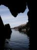
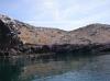
 The first cave I found on Isla San Idelfonzo
Links to related images: Nearby. Proofs. Map.
Approximate location: 26.63459N / 111.42791W.
 Blue footed boobies on Isla San Idelfonzo
Links to related images: Nearby. Proofs. Map.
Approximate location: 26.63468N / 111.42755W.
 Rock gardening around Isla San Idelfonzo
Links to related images: Nearby. Proofs. Map.
Approximate location: 26.63721N / 111.42873W.
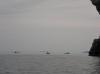
 Panga fisherman on Isla San Idelfonzo
Links to related images: Nearby. Proofs. Map.
Approximate location: 26.63826N / 111.43119W.
 Rock gardening around Isla San Idelfonzo
Links to related images: Nearby. Proofs. Map.
Approximate location: 26.63955N / 111.43282W.

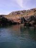
 The only easy landing I found on Isla San Idelfonzo
Links to related images: Nearby. Proofs. Map.
Approximate location: 26.64073N / 111.43437W.


 Rock gardening around Isla San Idelfonzo
Links to related images: Nearby. Proofs. Map.
Approximate location: 26.64148N / 111.43636W.
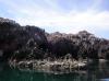
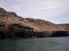
 The west shore of Isla San Idelfonzo has many caves
Links to related images: Nearby. Proofs. Map.
Approximate location: 26.63974N / 111.43591W.
 Birds nesting on Isla San Idelfonzo
Links to related images: Nearby. Proofs. Map.
Approximate location: 26.63768N / 111.43559W.
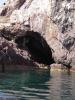
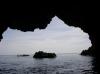
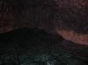
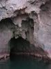
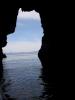
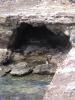
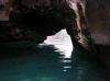
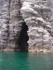
 Deep cave on Isla San Idelfonzo
Links to related images: Nearby. Proofs. Map.
Approximate location: 26.63773N / 111.43566W.
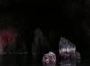
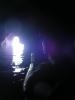 Self portrait of the intrepid kayaker in a cave on Isla San Idelfonzo
Links to related images: Nearby. Proofs. Map.
Approximate location: 26.63749N / 111.43557W.
 Deep cave on Isla San Idelfonzo
Links to related images: Nearby. Proofs. Map.
Approximate location: 26.63665N / 111.43445W.

 Rock gardening around Isla San Idelfonzo
Links to related images: Nearby. Proofs. Map.
Approximate location: 26.63706N / 111.43596W.
 The west shore of Isla San Idelfonzo has many caves
Links to related images: Nearby. Proofs. Map.
Approximate location: 26.63637N / 111.43617W.

 Frigate birds resting on Isla San Idelfonzo
Links to related images: Nearby. Proofs. Map.
Approximate location: 26.63723N / 111.43647W.


 Male frigate bird with red breeding chest
Links to related images: Nearby. Proofs. Map.
Approximate location: 26.6368N / 111.43662W.
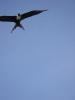 Frigate bird flying over Isla San Idelfonzo
Links to related images: Nearby. Proofs. Map.
Approximate location: 26.6368N / 111.43662W.

 Rock gardening around Isla San Idelfonzo
Links to related images: Nearby. Proofs. Map.
Approximate location: 26.63277N / 111.434W.
 The west shore of Isla San Idelfonzo has many caves
Links to related images: Nearby. Proofs. Map.
Approximate location: 26.63152N / 111.43259W.


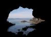

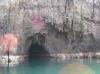
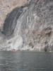
 Large cave in Isla San Idelfonzo with landing beach inside
Links to related images: Nearby. Proofs. Map.
Approximate location: 26.62899N / 111.42761W.


 Rock gardening around Isla San Idelfonzo
Links to related images: Nearby. Proofs. Map.
Approximate location: 26.62635N / 111.43064W.
 I made a seal landing on the reef to explore the light towers
Links to related images: Nearby. Proofs. Map.
Approximate location: 26.62494N / 111.42744W.
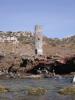
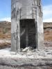
 The old concrete light tower on Isla San Idelfonzo
Links to related images: Nearby. Proofs. Map.
Approximate location: 26.62494N / 111.42744W.

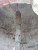
 Inside the old concrete light tower on Isla San Idelfonzo
Links to related images: Nearby. Proofs. Map.
Approximate location: 26.62494N / 111.42744W.
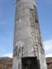
 The old concrete light tower on Isla San Idelfonzo
Links to related images: Nearby. Proofs. Map.
Approximate location: 26.62494N / 111.42744W.
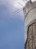
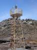 The new steel light tower on Isla San Idelfonzo
Links to related images: Nearby. Proofs. Map.
Approximate location: 26.62494N / 111.42744W.
 The old informative sign about Isla San Idelfonzo
Links to related images: Nearby. Proofs. Map.
Approximate location: 26.62494N / 111.42744W.
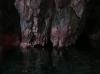
 Cave under the light towers on Isla San Idelfonzo
Links to related images: Nearby. Proofs. Map.
Approximate location: 26.62494N / 111.42746W.
 The ladder that used to ease landing on Isla San Idelfonzo
Links to related images: Nearby. Proofs. Map.
Approximate location: 26.62494N / 111.42746W.
 I can't say I'm sorry the new KEEP OFF sign was blown down by bad weather
Links to related images: Nearby. Proofs. Map.
Approximate location: 26.62494N / 111.42746W.
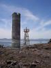 Light towers on Isla San Idelfonzo
Links to related images: Nearby. Proofs. Map.
Approximate location: 26.62494N / 111.42746W.
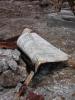
 Sea gull egg on Isla San Idelfonzo
Links to related images: Nearby. Proofs. Map.
Approximate location: 26.62494N / 111.42746W.
 I made a seal landing on the reef to explore the light towers
Links to related images: Nearby. Proofs. Map.
Approximate location: 26.62494N / 111.42746W.
 Panorama of the south tip of Isla San Idelfonzo
Links to related images: Nearby. Proofs. Map.
Approximate location: 26.62494N / 111.42746W.
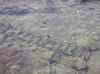
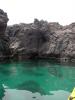 Clean green water at Punta San Antonio
Links to related images: Nearby. Proofs. Map.
Approximate location: 26.53675N / 111.46012W.
 Arch too small to paddle through at Punta San Antonio
Links to related images: Nearby. Proofs. Map.
Approximate location: 26.53668N / 111.46057W.
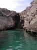
 Cave at Punta San Antonio
Links to related images: Nearby. Proofs. Map.
Approximate location: 26.53651N / 111.46042W.
 Arch too small to paddle through at Punta San Antonio
Links to related images: Nearby. Proofs. Map.
Approximate location: 26.53664N / 111.46059W.
 Punta San Antonio
Links to related images: Nearby. Proofs. Map.
Approximate location: 26.53627N / 111.46061W.
 Punta El Pulpito viewed from Punta San Antonio
Links to related images: Nearby. Proofs. Map.
Approximate location: 26.52842N / 111.45323W.
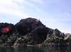
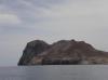
 Punta El Pulpito
Links to related images: Nearby. Proofs. Map.
Approximate location: 26.52063N / 111.44433W.
 Don Fleming came out to check on me at Punta El Pulpito
Links to related images: Nearby. Proofs. Map.
Approximate location: 26.52048N / 111.44415W.
 The big arch at Punta El Pulpito
Links to related images: Nearby. Proofs. Map.
Approximate location: 26.51866N / 111.44233W.
 Don Fleming came out to check on me at Punta El Pulpito
Links to related images: Nearby. Proofs. Map.
Approximate location: 26.51866N / 111.44233W.

 The big arch at Punta El Pulpito
Links to related images: Nearby. Proofs. Map.
Approximate location: 26.51823N / 111.44199W.
 The elephant trunk arch at Punta El Pulpito
Links to related images: Nearby. Proofs. Map.
Approximate location: 26.51632N / 111.44246W.
 Don Fleming came out to check on me at Punta El Pulpito
Links to related images: Nearby. Proofs. Map.
Approximate location: 26.5137N / 111.44548W.
 The elephant trunk arch at Punta El Pulpito
Links to related images: Nearby. Proofs. Map.
Approximate location: 26.5137N / 111.44548W.
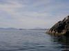
 Looking south from Punta El Pulpito
Links to related images: Nearby. Proofs. Map.
Approximate location: 26.51119N / 111.44973W.
 Our campsite near Punta El Pulpito
Links to related images: Nearby. Proofs. Map.
Approximate location: 26.50542N / 111.45578W.
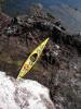
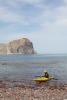 The intrepid kayaker landing behind Punta El Pulpito
Links to related images: Nearby. Proofs. Map.
Approximate location: 26.50538N / 111.45639W.
 The intrepid kayaker changing into paddling clothes
Links to related images: Nearby. Proofs. Map.
Approximate location: 26.50538N / 111.45639W.
All text and images Copyright © 2007 by Mike Higgins / contact