Cape Falcon to Tillamook Bay, August 8th 2007.
Click on the small image to see the full-sized one.
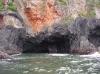
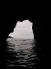
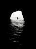
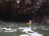
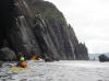
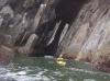 The intrepid kayaker exiting Pillar Cave in Cape Falcon, Oregon
Links to related images: Nearby. Proofs. Map.
Approximate location: 45.7618946134115N / 123.9816570282W.
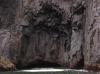
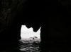
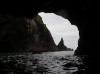
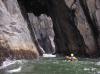
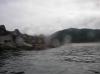
 The intrepid kayaker inside the long cave in Cape Falcon, Oregon
Links to related images: Nearby. Proofs. Map.
Approximate location: 45.7675828351477N / 123.98174285889W.
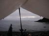 The view out the rain tarp on our Cape Falcon camping beach
Links to related images: Nearby. Proofs. Map.
Approximate location: 45.7658N / 123.98005W.
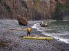
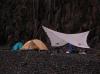 Our Cape Falcon camping spot
Links to related images: Nearby. Proofs. Map.
Approximate location: 45.7658N / 123.98005W.
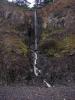 Waterfall over gravel beach on Cape Falcon
Links to related images: Nearby. Proofs. Map.
Approximate location: 45.7658N / 123.98005W.
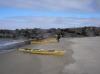
 Kayaks stored above the high tide on our Cape Falcon camping beach
Links to related images: Nearby. Proofs. Map.
Approximate location: 45.7658N / 123.98005W.
 Dick Ryon on our Cape Falcon camping beach
Links to related images: Nearby. Proofs. Map.
Approximate location: 45.7658N / 123.98005W.
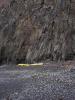
 The beach on Cape Falcon was littered with golf balls
Links to related images: Nearby. Proofs. Map.
Approximate location: 45.76585N / 123.98003W.
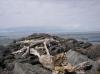
 Flotsam from the Cape Falcon beach
Links to related images: Nearby. Proofs. Map.
Approximate location: 45.76585N / 123.98003W.
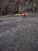
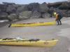
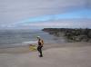
 Dick Ryon packing to launch from Cape Falcon
Links to related images: Nearby. Proofs. Map.
Approximate location: 45.76589N / 123.98157W.

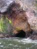
 Faceted basalt shapes in the cliffs of Cape Falcon
Links to related images: Nearby. Proofs. Map.
Approximate location: 45.7631N / 123.98198W.
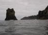
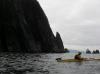
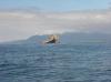
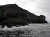 Rounding Cape Falcon
Links to related images: Nearby. Proofs. Map.
Approximate location: 45.76321N / 123.98297W.

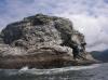
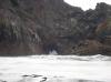 Big arch in Cape Falcon
Links to related images: Nearby. Proofs. Map.
Approximate location: 45.76297N / 123.98264W.

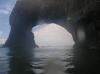
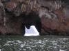 Devils Cauldron viewed through big arch in Cape Falcon
Links to related images: Nearby. Proofs. Map.
Approximate location: 45.76194N / 123.98191W.
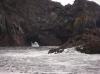
 Big arch in Cape Falcon
Links to related images: Nearby. Proofs. Map.
Approximate location: 45.76136N / 123.98108W.
 Dick Ryon going through the big arch in Cape Falcon
Links to related images: Nearby. Proofs. Map.
Approximate location: 45.761N / 123.98005W.
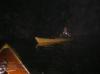
 Dick Ryon in Smuggler Cove
Links to related images: Nearby. Proofs. Map.
Approximate location: 45.76074N / 123.97906W.

 Holes in the cliffs at Devils Cauldron
Links to related images: Nearby. Proofs. Map.
Approximate location: 45.75284N / 123.96692W.

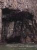
 Dick Ryon in huge cave in Devils Cauldron
Links to related images: Nearby. Proofs. Map.
Approximate location: 45.75265N / 123.96687W.

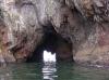
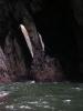
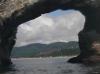
 Long cave goes clear through Devils Cauldron
Links to related images: Nearby. Proofs. Map.
Approximate location: 45.74943N / 123.96657W.
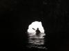
 Dick Ryon exiting the long cave at Devils Cauldron
Links to related images: Nearby. Proofs. Map.
Approximate location: 45.74943N / 123.96657W.
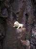
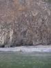
 Rocks at Devils Cauldron
Links to related images: Nearby. Proofs. Map.
Approximate location: 45.74995N / 123.96707W.
 Light through the big cave in Cape Falcon
Links to related images: Nearby. Proofs. Map.
Approximate location: 45.7495N / 123.96707W.

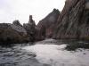 Rock gardening at Devils Cauldron
Links to related images: Nearby. Proofs. Map.
Approximate location: 45.74776N / 123.96636W.
 Dick Ryon rock gardening at Devils Cauldron
Links to related images: Nearby. Proofs. Map.
Approximate location: 45.74771N / 123.96627W.

 Dick Ryon in cave with basalt pillar
Links to related images: Nearby. Proofs. Map.
Approximate location: 45.74716N / 123.96537W.
 Dick Ryon rock gardening at Devils Cauldron
Links to related images: Nearby. Proofs. Map.
Approximate location: 45.74585N / 123.96475W.
 Dick Ryon in an arch at Devils Cauldron
Links to related images: Nearby. Proofs. Map.
Approximate location: 45.7452N / 123.96434W.
 Dick Ryon around the point at Devils Cauldron
Links to related images: Nearby. Proofs. Map.
Approximate location: 45.74458N / 123.96445W.
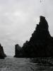
 Dramatic point at Devils Cauldron
Links to related images: Nearby. Proofs. Map.
Approximate location: 45.74411N / 123.96451W.
 Rounding the end of the Nehalem River south jetty
Links to related images: Nearby. Proofs. Map.
Approximate location: 45.65491N / 123.9443W.
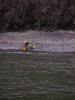
 Dick Ryon landed at the Nehalem River south jetty
Links to related images: Nearby. Proofs. Map.
Approximate location: 45.6548N / 123.94172W.
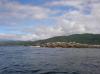
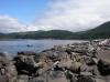 The Nehalem River viewed from the south jetty
Links to related images: Nearby. Proofs. Map.
Approximate location: 45.6548N / 123.94172W.
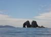
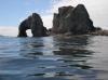


 Twin Rocks has a big arch
Links to related images: Nearby. Proofs. Map.
Approximate location: 45.59685N / 123.95938W.
 Dick Ryon in the Twin Rocks Arch
Links to related images: Nearby. Proofs. Map.
Approximate location: 45.59725N / 123.95915W.
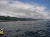
 Looking back at Twin Rocks
Links to related images: Nearby. Proofs. Map.
Approximate location: 45.58852N / 123.96048W.
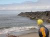
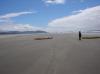
 The tip of the Tillamook Bay south jetty
Links to related images: Nearby. Proofs. Map.
Approximate location: 45.56663N / 123.96312W.
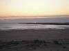
 The beach behind the Tillamook Bay south jetty
Links to related images: Nearby. Proofs. Map.
Approximate location: 45.56663N / 123.96299W.
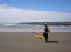
 Dick Ryon landed behind the Tillamook Bay south jetty
Links to related images: Nearby. Proofs. Map.
Approximate location: 45.56595N / 123.9582W.
 Dick Ryon in our sandy camp behind the Tillamook Bay south jetty
Links to related images: Nearby. Proofs. Map.
Approximate location: 45.56419N / 123.95029W.
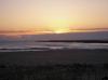
 Sunset from the dunes behind the Tillamook Bay south jetty
Links to related images: Nearby. Proofs. Map.
Approximate location: 45.56419N / 123.95029W.
All text and images Copyright © 2007 by Mike Higgins / contact