Cascade Head to Cape Foulweather, August 11th 2007.
Click on the small image to see the full-sized one.
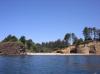
 Low point near Boiler Bay
Links to related images: Nearby.
Approximate location: 44.81368N / 124.06805W.
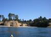
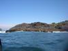
 The outside of Depoe Bay
Links to related images: Nearby.
Approximate location: 44.81358N / 124.06807W.
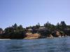
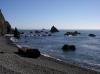
 Calm sandy beach in Whale Cove
Links to related images: Nearby.
Approximate location: 44.79109N / 124.07092W.
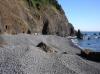
 Low point near Cape Foulweather
Links to related images: Nearby. Proofs. Map.
Approximate location: 44.78369N / 124.0747W.
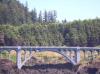 Highway 101 bridge ner Cape Foulweather
Links to related images: Nearby. Proofs. Map.
Approximate location: 44.77804N / 124.0742W.
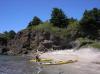
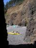
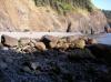
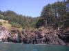 Rough shore of Cape Foulweather
Links to related images: Nearby. Proofs. Map.
Approximate location: 44.76731N / 124.07043W.
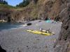
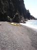 Kayaks landed on gravel beach at Cape Foulweather
Links to related images: Nearby. Proofs. Map.
Approximate location: 44.76663N / 124.06809W.
 Our gravel beach campsite on Cape Foulweather
Links to related images: Nearby. Proofs. Map.
Approximate location: 44.76695N / 124.06811W.
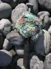 Flotsam on the beach at Cape Foulweather
Links to related images: Nearby. Proofs. Map.
Approximate location: 44.76695N / 124.06811W.
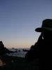 Dick Ryon in our Cape Foulweather camp in the evening
Links to related images: Nearby. Proofs. Map.
Approximate location: 44.76695N / 124.06811W.
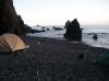 Our gravel beach campsite on Cape Foulweather
Links to related images: Nearby. Proofs. Map.
Approximate location: 44.76695N / 124.06811W.
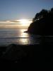 Sunset from our campsite on Cape Foulweather
Links to related images: Nearby. Proofs. Map.
Approximate location: 44.76695N / 124.06811W.
All text and images Copyright © 2007 by Mike Higgins / contact